
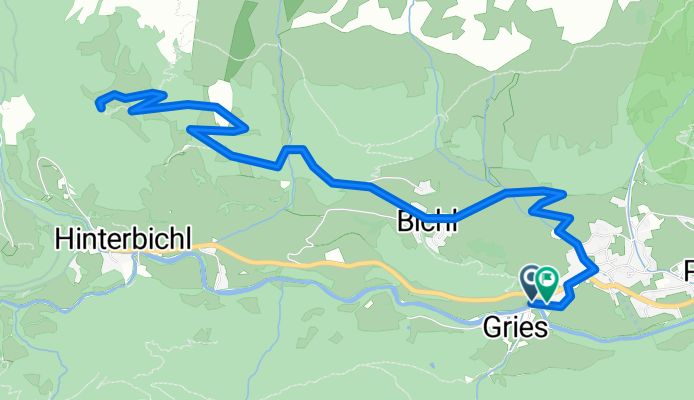
Sankt Andrä 42a nach Sankt Andrä 42a
A cycling route starting in Virgen, Tyrol, Austria.
Overview
About this route
- 1 h 12 min
- Duration
- 10.3 km
- Distance
- 665 m
- Ascent
- 673 m
- Descent
- 8.5 km/h
- Avg. speed
- 1,784 m
- Max. altitude

Route quality
Waytypes & surfaces along the route
Waytypes
Track
5.2 km
(51 %)
Quiet road
4.3 km
(42 %)
Surfaces
Paved
3.7 km
(36 %)
Unpaved
5.2 km
(51 %)
Gravel
5.2 km
(51 %)
Asphalt
3.7 km
(36 %)
Undefined
1.3 km
(13 %)
Continue with Bikemap
Use, edit, or download this cycling route
You would like to ride Sankt Andrä 42a nach Sankt Andrä 42a or customize it for your own trip? Here is what you can do with this Bikemap route:
Free features
- Save this route as favorite or in collections
- Copy & plan your own version of this route
- Sync your route with Garmin or Wahoo
Premium features
Free trial for 3 days, or one-time payment. More about Bikemap Premium.
- Navigate this route on iOS & Android
- Export a GPX / KML file of this route
- Create your custom printout (try it for free)
- Download this route for offline navigation
Discover more Premium features.
Get Bikemap PremiumFrom our community
Other popular routes starting in Virgen
 Prägraten - Matrei retour
- Distance
- 25.3 km
- Ascent
- 488 m
- Descent
- 488 m
- Location
- Virgen, Tyrol, Austria
 Niedermauern-Gries 2 nach Unnamed Road
- Distance
- 9.4 km
- Ascent
- 1,037 m
- Descent
- 12 m
- Location
- Virgen, Tyrol, Austria
 Virgen Matrei Goldried Thörl Kals Huben Virgen
- Distance
- 58.6 km
- Ascent
- 1,779 m
- Descent
- 1,800 m
- Location
- Virgen, Tyrol, Austria
 Sankt Andrä 42a nach Sankt Andrä 42a
- Distance
- 10.3 km
- Ascent
- 665 m
- Descent
- 673 m
- Location
- Virgen, Tyrol, Austria
 Virgen_Wetterkreuzhütte
- Distance
- 11.3 km
- Ascent
- 1,034 m
- Descent
- 151 m
- Location
- Virgen, Tyrol, Austria
 Tratteweg 20 nach Unnamed Road
- Distance
- 8.2 km
- Ascent
- 1,091 m
- Descent
- 0 m
- Location
- Virgen, Tyrol, Austria
 Staller Sattel
- Distance
- 18.8 km
- Ascent
- 881 m
- Descent
- 161 m
- Location
- Virgen, Tyrol, Austria
 pragraten-johannishutte
- Distance
- 7.2 km
- Ascent
- 870 m
- Descent
- 88 m
- Location
- Virgen, Tyrol, Austria
Open it in the app