
Von Apetlon bis Saint-Jean-Pied-de-Port
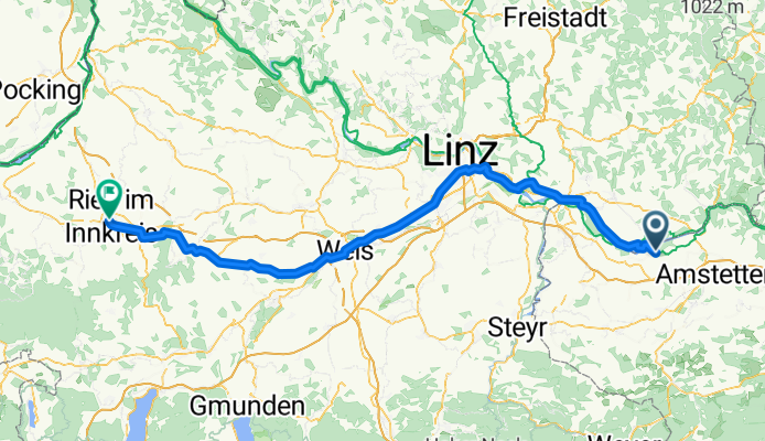
Zeillern - Ried im Innkreis
A cycling route starting in Zeillern, Lower Austria, Austria.
Overview
About this route
- 6 h 48 min
- Duration
- 120.6 km
- Distance
- 890 m
- Ascent
- 688 m
- Descent
- 17.7 km/h
- Avg. speed
- 617 m
- Max. altitude

Part of
Route quality
Waytypes & surfaces along the route
Waytypes
Quiet road
43.4 km
(36 %)
Cycleway
35 km
(29 %)
Surfaces
Paved
80.8 km
(67 %)
Asphalt
77.2 km
(64 %)
Paved (undefined)
3.6 km
(3 %)
Undefined
39.8 km
(33 %)
Continue with Bikemap
Use, edit, or download this cycling route
You would like to ride Zeillern - Ried im Innkreis or customize it for your own trip? Here is what you can do with this Bikemap route:
Free features
- Save this route as favorite or in collections
- Copy & plan your own version of this route
- Split it into stages to create a multi-day tour
- Sync your route with Garmin or Wahoo
Premium features
Free trial for 3 days, or one-time payment. More about Bikemap Premium.
- Navigate this route on iOS & Android
- Export a GPX / KML file of this route
- Create your custom printout (try it for free)
- Download this route for offline navigation
Discover more Premium features.
Get Bikemap PremiumFrom our community
Other popular routes starting in Zeillern
 Mauer-Weistrach
- Distance
- 74.1 km
- Ascent
- 741 m
- Descent
- 743 m
- Location
- Zeillern, Lower Austria, Austria
 Zeillern - Ried im Innkreis
- Distance
- 120.6 km
- Ascent
- 890 m
- Descent
- 688 m
- Location
- Zeillern, Lower Austria, Austria
 Oed Amstetten - Pochlam
- Distance
- 55.8 km
- Ascent
- 731 m
- Descent
- 910 m
- Location
- Zeillern, Lower Austria, Austria
 Niedersulzfahrt
- Distance
- 195.2 km
- Ascent
- 294 m
- Descent
- 349 m
- Location
- Zeillern, Lower Austria, Austria
 48.163° N 14.819° W to 48.209° N 15.216° W
- Distance
- 51.2 km
- Ascent
- 317 m
- Descent
- 361 m
- Location
- Zeillern, Lower Austria, Austria
 Aschbach, Kröllendorf, Neuhofen
- Distance
- 32.9 km
- Ascent
- 138 m
- Descent
- 139 m
- Location
- Zeillern, Lower Austria, Austria
 Neustadtl-Grein-Klam-Baumgartenberg
- Distance
- 64.3 km
- Ascent
- 698 m
- Descent
- 698 m
- Location
- Zeillern, Lower Austria, Austria
 Doppstein-Grein-Persenbeug-Ybbs-Doppstein
- Distance
- 60.3 km
- Ascent
- 231 m
- Descent
- 233 m
- Location
- Zeillern, Lower Austria, Austria
Open it in the app