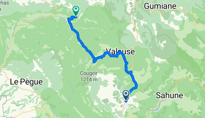
Ventoux, Paname, part 1
Condorcet, La Paillette
A cycling route starting in Condorcet, Auvergne-Rh么ne-Alpes, France.
Overview
About this route
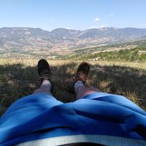
Exactly! Nice coordination. Col de Valouse. I stopped to make a sketch. 300 m of elevation gain and still heavily loaded panniers. Hihi, the path starts with a road in a shaded gorge. Top!
Great pass! Wow, magnificent and slopes of at least 20, 30%. Even alone without a bike it was tough. There's a village, mailboxes, trees, and a fountain. I'm getting ready for the descent. I'm starving.
- 1 h 34 min
- Duration
- 21 km
- Distance
- 868 m
- Ascent
- 578 m
- Descent
- 13.4 km/h
- Avg. speed
- 772 m
- Max. altitude
Part of
7 stages
Route photos
Route quality
Waytypes & surfaces along the route
Waytypes
Road
13.2 km
(63 %)
Quiet road
2.1 km
(10 %)
Surfaces
Paved
4.2 km
(20 %)
Asphalt
4.2 km
(20 %)
Undefined
16.8 km
(80 %)
Continue with Bikemap
Use, edit, or download this cycling route
You would like to ride Condorcet, La Paillette or customize it for your own trip? Here is what you can do with this Bikemap route:
Free features
- Save this route as favorite or in collections
- Copy & plan your own version of this route
- Sync your route with Garmin or Wahoo
Premium features
Free trial for 3 days, or one-time payment. More about Bikemap Premium.
- Navigate this route on iOS & Android
- Export a GPX / KML file of this route
- Create your custom printout (try it for free)
- Download this route for offline navigation
Discover more Premium features.
Get Bikemap PremiumFrom our community
Other popular routes starting in Condorcet
- Roserai-Drome - Valouse
- Distance
- 26.6 km
- Ascent
- 486 m
- Descent
- 483 m
- Location
- Condorcet, Auvergne-Rh么ne-Alpes, France
- 2014 Sainte Jalle Ost
- Distance
- 104.9 km
- Ascent
- 1,277 m
- Descent
- 1,276 m
- Location
- Condorcet, Auvergne-Rh么ne-Alpes, France
- Condorcet, La Paillette
- Distance
- 21 km
- Ascent
- 868 m
- Descent
- 578 m
- Location
- Condorcet, Auvergne-Rh么ne-Alpes, France
- R茅muzat_v2_20sept14
- Distance
- 60.8 km
- Ascent
- 787 m
- Descent
- 787 m
- Location
- Condorcet, Auvergne-Rh么ne-Alpes, France
- LA MOTTE ST NAZAIRE
- Distance
- 49.9 km
- Ascent
- 938 m
- Descent
- 938 m
- Location
- Condorcet, Auvergne-Rh么ne-Alpes, France
- Circuit 1
- Distance
- 60.3 km
- Ascent
- 824 m
- Descent
- 823 m
- Location
- Condorcet, Auvergne-Rh么ne-Alpes, France
- VERSION FINALE LA MOTTE SERRES
- Distance
- 62.4 km
- Ascent
- 2,315 m
- Descent
- 2,211 m
- Location
- Condorcet, Auvergne-Rh么ne-Alpes, France
- Remuzat - Col de Soubeyrand
- Distance
- 42.5 km
- Ascent
- 765 m
- Descent
- 756 m
- Location
- Condorcet, Auvergne-Rh么ne-Alpes, France
Open it in the app