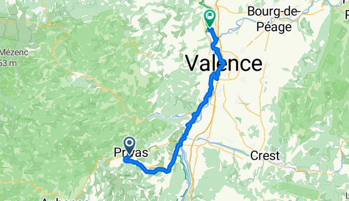
Ventoux, Paname, part 1
Privas, La Roche-de-Glun
A cycling route starting in Privas, Auvergne-Rhône-Alpes, France.
Overview
About this route
I just saw a snake – green, yellow, about 1 meter long – on the bike path along the Eyrieux river. Keep this information to yourself. It freaks me out too much. Otherwise, I'm moving slowly. I'm drawing and getting stubbornly bored. Yesterday I had a beer and a decent pizza in the Poussin (?) parking lot before heading up a great trail in Privas. Well, beer actually makes you thirsty! Lol. Valence in sight! Kisses PS: The Paleolithic museum in La Voulte-sur-Rhône is a myth. It closed 15 years ago! MF. There is no Paleolithic museum in La Voulte-sur-Rhône!!! (I'm totally disappointed)
- 4 h 5 min
- Duration
- 68.2 km
- Distance
- 439 m
- Ascent
- 631 m
- Descent
- 16.7 km/h
- Avg. speed
- 309 m
- Max. altitude
Part of
7 stages
Route photos
Route quality
Waytypes & surfaces along the route
Waytypes
Cycleway
28.6 km
(42 %)
Path
21.8 km
(32 %)
Surfaces
Paved
45.7 km
(67 %)
Unpaved
2 km
(3 %)
Asphalt
45.7 km
(67 %)
Loose gravel
1.4 km
(2 %)
Continue with Bikemap
Use, edit, or download this cycling route
You would like to ride Privas, La Roche-de-Glun or customize it for your own trip? Here is what you can do with this Bikemap route:
Free features
- Save this route as favorite or in collections
- Copy & plan your own version of this route
- Sync your route with Garmin or Wahoo
Premium features
Free trial for 3 days, or one-time payment. More about Bikemap Premium.
- Navigate this route on iOS & Android
- Export a GPX / KML file of this route
- Create your custom printout (try it for free)
- Download this route for offline navigation
Discover more Premium features.
Get Bikemap PremiumFrom our community
Other popular routes starting in Privas
- PRIVAS - LES OLLIERES SUR HEYRIEUX
- Distance
- 48.5 km
- Ascent
- 449 m
- Descent
- 542 m
- Location
- Privas, Auvergne-Rhône-Alpes, France
- Ardechoise 3 moyen
- Distance
- 118.7 km
- Ascent
- 2,323 m
- Descent
- 1,587 m
- Location
- Privas, Auvergne-Rhône-Alpes, France
- Parcours du 30 juillet 2011
- Distance
- 92.9 km
- Ascent
- 1,548 m
- Descent
- 1,548 m
- Location
- Privas, Auvergne-Rhône-Alpes, France
- Privas - Sainte-Enimie
- Distance
- 174.5 km
- Ascent
- 2,041 m
- Descent
- 1,862 m
- Location
- Privas, Auvergne-Rhône-Alpes, France
- Privas, Pourcheres, Coiron, Privas
- Distance
- 65.2 km
- Ascent
- 1,018 m
- Descent
- 1,012 m
- Location
- Privas, Auvergne-Rhône-Alpes, France
- Ardéchoise buissonnière J2
- Distance
- 128.8 km
- Ascent
- 1,658 m
- Descent
- 1,346 m
- Location
- Privas, Auvergne-Rhône-Alpes, France
- Privas - Baron - Privas - Freyssenet - Aubenas - Privas
- Distance
- 87.2 km
- Ascent
- 1,732 m
- Descent
- 1,733 m
- Location
- Privas, Auvergne-Rhône-Alpes, France
- Privas, La Roche-de-Glun
- Distance
- 68.2 km
- Ascent
- 439 m
- Descent
- 631 m
- Location
- Privas, Auvergne-Rhône-Alpes, France
Open it in the app