
Ventoux, Paname, part 1
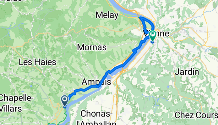
Condrieu, Vienne
A cycling route starting in Condrieu, Auvergne-Rhône-Alpes, France.
Overview
About this route
Ah no, I didn't look on the website. Well yeah, I'm not going to light my camping stove out in the open public. I don't feel comfortable with that...
I'm at the Gallo-Roman museum of Saint Romain en Gal. Plan: I'm taking the train at noon to Lyon and Roanne. I called a campsite on the list... otherwise no worries.
- 1 h 6 min
- Duration
- 18.3 km
- Distance
- 140 m
- Ascent
- 125 m
- Descent
- 16.7 km/h
- Avg. speed
- 190 m
- Max. altitude

Part of
7 stages
Route photos

Route quality
Waytypes & surfaces along the route
Waytypes
Quiet road
11.3 km
(62 %)
Access road
2.4 km
(13 %)
Surfaces
Paved
16.8 km
(92 %)
Asphalt
16.6 km
(91 %)
Concrete
0.2 km
(1 %)
Undefined
1.5 km
(8 %)
Continue with Bikemap
Use, edit, or download this cycling route
You would like to ride Condrieu, Vienne or customize it for your own trip? Here is what you can do with this Bikemap route:
Free features
- Save this route as favorite or in collections
- Copy & plan your own version of this route
- Sync your route with Garmin or Wahoo
Premium features
Free trial for 3 days, or one-time payment. More about Bikemap Premium.
- Navigate this route on iOS & Android
- Export a GPX / KML file of this route
- Create your custom printout (try it for free)
- Download this route for offline navigation
Discover more Premium features.
Get Bikemap PremiumFrom our community
Other popular routes starting in Condrieu
 Ile du Beurre - Montélimar (FR-MA9)
- Distance
- 160 km
- Ascent
- 35 m
- Descent
- 111 m
- Location
- Condrieu, Auvergne-Rhône-Alpes, France
 J4C RC2MIPIM 2018
- Distance
- 31.2 km
- Ascent
- 35 m
- Descent
- 47 m
- Location
- Condrieu, Auvergne-Rhône-Alpes, France
 4. Tag Rhone
- Distance
- 50.1 km
- Ascent
- 204 m
- Descent
- 336 m
- Location
- Condrieu, Auvergne-Rhône-Alpes, France
 16) Condrieu - Valence
- Distance
- 80.7 km
- Ascent
- 93 m
- Descent
- 135 m
- Location
- Condrieu, Auvergne-Rhône-Alpes, France
 ViaRhona-5
- Distance
- 79.4 km
- Ascent
- 219 m
- Descent
- 235 m
- Location
- Condrieu, Auvergne-Rhône-Alpes, France
 Etape 14 - Condrieu à Montmerle sur Saône - 89,8km 120D+
- Distance
- 89.8 km
- Ascent
- 145 m
- Descent
- 119 m
- Location
- Condrieu, Auvergne-Rhône-Alpes, France
 Rhone 1/3
- Distance
- 78.3 km
- Ascent
- 92 m
- Descent
- 128 m
- Location
- Condrieu, Auvergne-Rhône-Alpes, France
 b1 Via Rhona au départ de Condrieu
- Distance
- 45.6 km
- Ascent
- 211 m
- Descent
- 214 m
- Location
- Condrieu, Auvergne-Rhône-Alpes, France
Open it in the app