
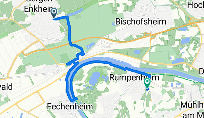
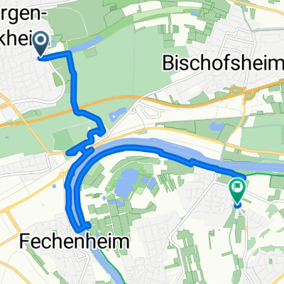
Von Frankfurt am Main bis Rumpenheim
A cycling route starting in Bad Vilbel, Hesse, Germany.
Overview
About this route
- 46 min
- Duration
- 9.6 km
- Distance
- 16 m
- Ascent
- 14 m
- Descent
- 12.7 km/h
- Avg. speed
- 109 m
- Max. altitude
Route quality
Waytypes & surfaces along the route
Waytypes
Path
3.2 km
(33 %)
Track
1.9 km
(20 %)
Surfaces
Paved
4.9 km
(51 %)
Unpaved
1.6 km
(17 %)
Asphalt
4.6 km
(48 %)
Gravel
1.5 km
(16 %)
Continue with Bikemap
Use, edit, or download this cycling route
You would like to ride Von Frankfurt am Main bis Rumpenheim or customize it for your own trip? Here is what you can do with this Bikemap route:
Free features
- Save this route as favorite or in collections
- Copy & plan your own version of this route
- Sync your route with Garmin or Wahoo
Premium features
Free trial for 3 days, or one-time payment. More about Bikemap Premium.
- Navigate this route on iOS & Android
- Export a GPX / KML file of this route
- Create your custom printout (try it for free)
- Download this route for offline navigation
Discover more Premium features.
Get Bikemap PremiumFrom our community
Other popular routes starting in Bad Vilbel
 Wetterau-Acht (RB 056 - 550)
- Distance
- 56 km
- Ascent
- 269 m
- Descent
- 268 m
- Location
- Bad Vilbel, Hesse, Germany
 Von Frankfurt am Main bis Rumpenheim
- Distance
- 9.6 km
- Ascent
- 16 m
- Descent
- 14 m
- Location
- Bad Vilbel, Hesse, Germany
 Harheim Airport
- Distance
- 86.5 km
- Ascent
- 276 m
- Descent
- 277 m
- Location
- Bad Vilbel, Hesse, Germany
 Römerkastell Saalburg_ImM_T_via Bonames, Eschbach, Kirdorf
- Distance
- 19.1 km
- Ascent
- 355 m
- Descent
- 39 m
- Location
- Bad Vilbel, Hesse, Germany
 BW Depot - Friedrichstahl - Wiesental
- Distance
- 68.3 km
- Ascent
- 629 m
- Descent
- 629 m
- Location
- Bad Vilbel, Hesse, Germany
 Route in Frankfurt am Main
- Distance
- 31.3 km
- Ascent
- 52 m
- Descent
- 51 m
- Location
- Bad Vilbel, Hesse, Germany
 Vogelsberg
- Distance
- 149.8 km
- Ascent
- 1,064 m
- Descent
- 1,064 m
- Location
- Bad Vilbel, Hesse, Germany
 R.Anglerheim am Nidda_ImM_T_N_via nur Nidda
- Distance
- 10.6 km
- Ascent
- 25 m
- Descent
- 44 m
- Location
- Bad Vilbel, Hesse, Germany
Open it in the app