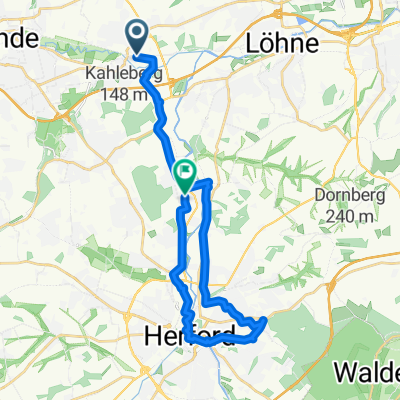
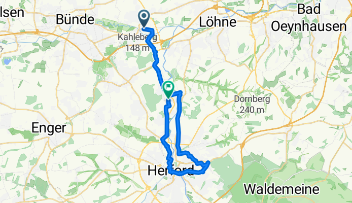
Hiddenhsn_Stuckenberg
A cycling route starting in Kirchlengern, North Rhine-Westphalia, Germany.
Overview
About this route
- 1 h 19 min
- Duration
- 21.4 km
- Distance
- 139 m
- Ascent
- 129 m
- Descent
- 16.3 km/h
- Avg. speed
- 128 m
- Max. altitude
Route quality
Waytypes & surfaces along the route
Waytypes
Quiet road
8.9 km
(42 %)
Path
6.6 km
(31 %)
Surfaces
Paved
16.7 km
(78 %)
Unpaved
1.3 km
(6 %)
Asphalt
16.5 km
(77 %)
Gravel
1 km
(5 %)
Continue with Bikemap
Use, edit, or download this cycling route
You would like to ride Hiddenhsn_Stuckenberg or customize it for your own trip? Here is what you can do with this Bikemap route:
Free features
- Save this route as favorite or in collections
- Copy & plan your own version of this route
- Sync your route with Garmin or Wahoo
Premium features
Free trial for 3 days, or one-time payment. More about Bikemap Premium.
- Navigate this route on iOS & Android
- Export a GPX / KML file of this route
- Create your custom printout (try it for free)
- Download this route for offline navigation
Discover more Premium features.
Get Bikemap PremiumFrom our community
Other popular routes starting in Kirchlengern
- Ein Stück von BoB
- Distance
- 111 km
- Ascent
- 1,279 m
- Descent
- 1,294 m
- Location
- Kirchlengern, North Rhine-Westphalia, Germany
- Bünde nach Springe
- Distance
- 104.3 km
- Ascent
- 581 m
- Descent
- 505 m
- Location
- Kirchlengern, North Rhine-Westphalia, Germany
- Kirchlengern nach Jöllenbeck Rundkurs
- Distance
- 38.7 km
- Ascent
- 244 m
- Descent
- 244 m
- Location
- Kirchlengern, North Rhine-Westphalia, Germany
- Kaiser-Wilhem Denkmal
- Distance
- 52 km
- Ascent
- 139 m
- Descent
- 138 m
- Location
- Kirchlengern, North Rhine-Westphalia, Germany
- Elsestraße nach Tannenweg
- Distance
- 17.7 km
- Ascent
- 89 m
- Descent
- 96 m
- Location
- Kirchlengern, North Rhine-Westphalia, Germany
- Hiddenhsn_Stuckenberg
- Distance
- 21.4 km
- Ascent
- 139 m
- Descent
- 129 m
- Location
- Kirchlengern, North Rhine-Westphalia, Germany
- Von Kirchlengern bis Rödinghausen
- Distance
- 17.4 km
- Ascent
- 138 m
- Descent
- 55 m
- Location
- Kirchlengern, North Rhine-Westphalia, Germany
- Der Wadenbeißer
- Distance
- 26.5 km
- Ascent
- 300 m
- Descent
- 316 m
- Location
- Kirchlengern, North Rhine-Westphalia, Germany
Open it in the app