
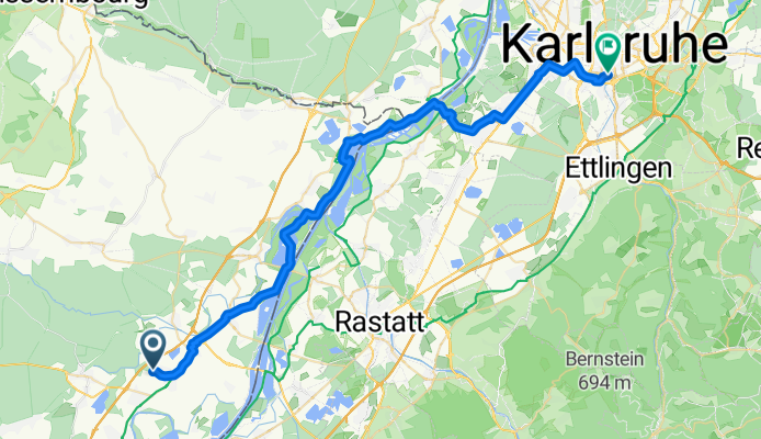
Von Rœschwoog bis Karlsruhe
A cycling route starting in Roppenheim, Grand Est, France.
Overview
About this route
- 2 h 28 min
- Duration
- 44.9 km
- Distance
- 79 m
- Ascent
- 76 m
- Descent
- 18.2 km/h
- Avg. speed
- 121 m
- Max. altitude

Route quality
Waytypes & surfaces along the route
Waytypes
Cycleway
13 km
(29 %)
Path
10.3 km
(23 %)
Surfaces
Paved
41.3 km
(92 %)
Asphalt
38.6 km
(86 %)
Paved (undefined)
2.2 km
(5 %)
Continue with Bikemap
Use, edit, or download this cycling route
You would like to ride Von Rœschwoog bis Karlsruhe or customize it for your own trip? Here is what you can do with this Bikemap route:
Free features
- Save this route as favorite or in collections
- Copy & plan your own version of this route
- Sync your route with Garmin or Wahoo
Premium features
Free trial for 3 days, or one-time payment. More about Bikemap Premium.
- Navigate this route on iOS & Android
- Export a GPX / KML file of this route
- Create your custom printout (try it for free)
- Download this route for offline navigation
Discover more Premium features.
Get Bikemap PremiumFrom our community
Other popular routes starting in Roppenheim
 Elsass, 22. Juni 2025
- Distance
- 52.3 km
- Ascent
- 117 m
- Descent
- 96 m
- Location
- Roppenheim, Grand Est, France
 Stall über Kaufenheim
- Distance
- 6.9 km
- Ascent
- 0 m
- Descent
- 0 m
- Location
- Roppenheim, Grand Est, France
 Roppenheim Fort-Louis 27km
- Distance
- 26.6 km
- Ascent
- 4 m
- Descent
- 5 m
- Location
- Roppenheim, Grand Est, France
 3 rastatt / neuhaus am inn
- Distance
- 476.8 km
- Ascent
- 1,027 m
- Descent
- 836 m
- Location
- Roppenheim, Grand Est, France
 donau route
- Distance
- 34.8 km
- Ascent
- 220 m
- Descent
- 228 m
- Location
- Roppenheim, Grand Est, France
 SAP
SAP- Distance
- 33.8 km
- Ascent
- 61 m
- Descent
- 55 m
- Location
- Roppenheim, Grand Est, France
 Pamina Rheinradweg Iffezheim-Wörth
- Distance
- 95.2 km
- Ascent
- 71 m
- Descent
- 93 m
- Location
- Roppenheim, Grand Est, France
 Wintersdorf 67Km / 310m
- Distance
- 67.8 km
- Ascent
- 345 m
- Descent
- 345 m
- Location
- Roppenheim, Grand Est, France
Open it in the app