
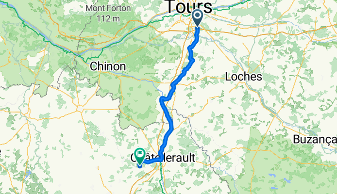
From Paris to Couloumé-Mondebat
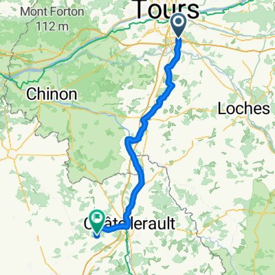
Chambray-lès-Tours - Colombiers
A cycling route starting in Chambray-lès-Tours, Centre Region, France.
Overview
About this route
- 4 h 50 min
- Duration
- 83.8 km
- Distance
- 301 m
- Ascent
- 327 m
- Descent
- 17.3 km/h
- Avg. speed
- 123 m
- Max. altitude
Part of
From Paris to Couloumé-Mondebat
13 stages
Route quality
Waytypes & surfaces along the route
Waytypes
Quiet road
38.5 km
(46 %)
Road
33.4 km
(40 %)
Surfaces
Paved
20 km
(24 %)
Asphalt
19.6 km
(23 %)
Paved (undefined)
0.4 km
(<1 %)
Undefined
63.8 km
(76 %)
Continue with Bikemap
Use, edit, or download this cycling route
You would like to ride Chambray-lès-Tours - Colombiers or customize it for your own trip? Here is what you can do with this Bikemap route:
Free features
- Save this route as favorite or in collections
- Copy & plan your own version of this route
- Split it into stages to create a multi-day tour
- Sync your route with Garmin or Wahoo
Premium features
Free trial for 3 days, or one-time payment. More about Bikemap Premium.
- Navigate this route on iOS & Android
- Export a GPX / KML file of this route
- Create your custom printout (try it for free)
- Download this route for offline navigation
Discover more Premium features.
Get Bikemap PremiumFrom our community
Other popular routes starting in Chambray-lès-Tours
 Chambray-lès-Tours - Colombiers
- Distance
- 83.8 km
- Ascent
- 301 m
- Descent
- 327 m
- Location
- Chambray-lès-Tours, Centre Region, France
 Déplacement à Leroy Merlin
- Distance
- 4.6 km
- Ascent
- 22 m
- Descent
- 28 m
- Location
- Chambray-lès-Tours, Centre Region, France
 Tours - Nantes Experimental
- Distance
- 238.3 km
- Ascent
- 204 m
- Descent
- 287 m
- Location
- Chambray-lès-Tours, Centre Region, France
 Route in Chambray-lès-Tours
- Distance
- 58.6 km
- Ascent
- 359 m
- Descent
- 357 m
- Location
- Chambray-lès-Tours, Centre Region, France
 1 Rue Jean Perrin, Chambray-lès-Tours à Rue de la Manse, Noyant-de-Touraine
- Distance
- 36 km
- Ascent
- 198 m
- Descent
- 229 m
- Location
- Chambray-lès-Tours, Centre Region, France
 Route des Barons, Joué-lès-Tours à 22 Rue du Gravier, Joué-lès-Tours
- Distance
- 4 km
- Ascent
- 27 m
- Descent
- 27 m
- Location
- Chambray-lès-Tours, Centre Region, France
 De Rue du Fer À Cheval 6, Chambray-lès-Tours à Place de la Mairie 3, Cinq-Mars-la-Pile
- Distance
- 23.6 km
- Ascent
- 85 m
- Descent
- 120 m
- Location
- Chambray-lès-Tours, Centre Region, France
 Circuit 28/12/2014
- Distance
- 30.2 km
- Ascent
- 85 m
- Descent
- 84 m
- Location
- Chambray-lès-Tours, Centre Region, France
Open it in the app