

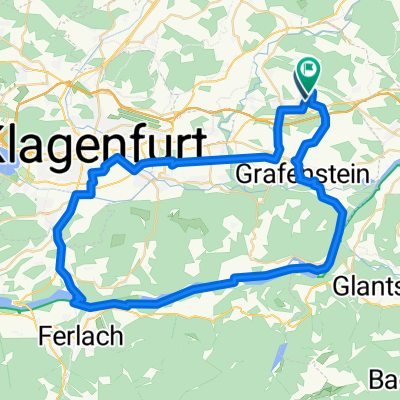
Pischeldorf-Griffner-Lavanttal-Klippitztörl
A cycling route starting in Poggersdorf, Carinthia, Austria.
Overview
About this route
From Pischeldorf towards Brückl, then east to Klein St. Veit, Griffen via Griffner through the Lavant valley before Bad St. Leonhard, west over Klippitztörl and back through the Görtschitztal valley.
- -:--
- Duration
- 125.2 km
- Distance
- 1,497 m
- Ascent
- 1,495 m
- Descent
- ---
- Avg. speed
- ---
- Max. altitude

Route quality
Waytypes & surfaces along the route
Waytypes
Cycleway
7.5 km
(6 %)
Quiet road
3.8 km
(3 %)
Surfaces
Paved
45.1 km
(36 %)
Asphalt
45.1 km
(36 %)
Undefined
80.1 km
(64 %)
Continue with Bikemap
Use, edit, or download this cycling route
You would like to ride Pischeldorf-Griffner-Lavanttal-Klippitztörl or customize it for your own trip? Here is what you can do with this Bikemap route:
Free features
- Save this route as favorite or in collections
- Copy & plan your own version of this route
- Split it into stages to create a multi-day tour
- Sync your route with Garmin or Wahoo
Premium features
Free trial for 3 days, or one-time payment. More about Bikemap Premium.
- Navigate this route on iOS & Android
- Export a GPX / KML file of this route
- Create your custom printout (try it for free)
- Download this route for offline navigation
Discover more Premium features.
Get Bikemap PremiumFrom our community
Other popular routes starting in Poggersdorf
 KLAGENFURT - FRIESACH
- Distance
- 50.2 km
- Ascent
- 360 m
- Descent
- 162 m
- Location
- Poggersdorf, Carinthia, Austria
 Kitzelberg über Grafenstein
- Distance
- 26.5 km
- Ascent
- 696 m
- Descent
- 461 m
- Location
- Poggersdorf, Carinthia, Austria
 Pischeldorf-Griffner-Lavanttal-Klippitztörl
- Distance
- 125.2 km
- Ascent
- 1,497 m
- Descent
- 1,495 m
- Location
- Poggersdorf, Carinthia, Austria
 Schnelle Tour st. marharethen-korb
- Distance
- 30.9 km
- Ascent
- 24 m
- Descent
- 0 m
- Location
- Poggersdorf, Carinthia, Austria
 Walter
- Distance
- 80.9 km
- Ascent
- 569 m
- Descent
- 487 m
- Location
- Poggersdorf, Carinthia, Austria
 Leibsdorf-Tainach-Grafenstein-Rain-Sillebrücke
- Distance
- 27.7 km
- Ascent
- 97 m
- Descent
- 97 m
- Location
- Poggersdorf, Carinthia, Austria
 Ferlach > Helene
- Distance
- 58.6 km
- Ascent
- 468 m
- Descent
- 467 m
- Location
- Poggersdorf, Carinthia, Austria
 Tainach
- Distance
- 44.3 km
- Ascent
- 304 m
- Descent
- 304 m
- Location
- Poggersdorf, Carinthia, Austria
Open it in the app