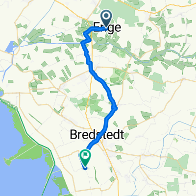
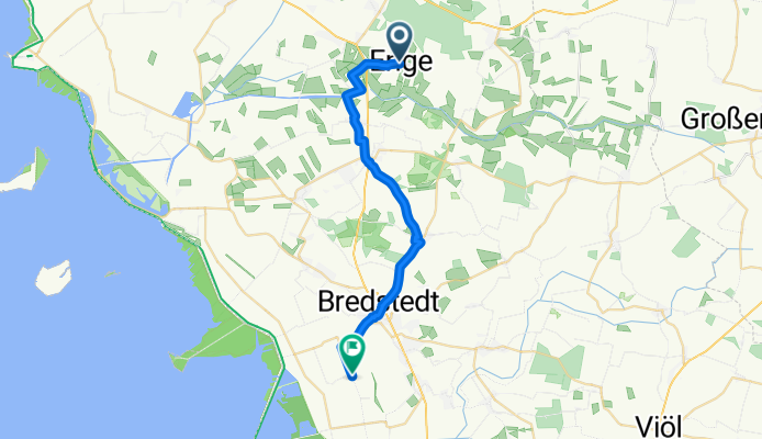
From Enge-Sande to Reußenköge
A cycling route starting in Bargum, Schleswig-Holstein, Germany.
Overview
About this route
- 1 h 16 min
- Duration
- 21.5 km
- Distance
- 46 m
- Ascent
- 48 m
- Descent
- 17 km/h
- Avg. speed
- 41 m
- Max. altitude
Route quality
Waytypes & surfaces along the route
Waytypes
Quiet road
12.5 km
(58 %)
Path
7 km
(33 %)
Surfaces
Paved
3.9 km
(18 %)
Paved (undefined)
3.5 km
(17 %)
Asphalt
0.4 km
(2 %)
Undefined
17.6 km
(82 %)
Continue with Bikemap
Use, edit, or download this cycling route
You would like to ride From Enge-Sande to Reußenköge or customize it for your own trip? Here is what you can do with this Bikemap route:
Free features
- Save this route as favorite or in collections
- Copy & plan your own version of this route
- Sync your route with Garmin or Wahoo
Premium features
Free trial for 3 days, or one-time payment. More about Bikemap Premium.
- Navigate this route on iOS & Android
- Export a GPX / KML file of this route
- Create your custom printout (try it for free)
- Download this route for offline navigation
Discover more Premium features.
Get Bikemap PremiumFrom our community
Other popular routes starting in Bargum
- 05_EngeSande_Wesselburen
- Distance
- 77.1 km
- Ascent
- 55 m
- Descent
- 62 m
- Location
- Bargum, Schleswig-Holstein, Germany
- 4.8.2013 Langenhorn - Leck - Bramstedtlund - Sæd - Aventoft - Fahrtoft - Langenhorn
- Distance
- 98.6 km
- Ascent
- 35 m
- Descent
- 34 m
- Location
- Bargum, Schleswig-Holstein, Germany
- Enge-Sande Wald
- Distance
- 9.4 km
- Ascent
- 84 m
- Descent
- 85 m
- Location
- Bargum, Schleswig-Holstein, Germany
- From Enge-Sande to Reußenköge
- Distance
- 21.5 km
- Ascent
- 46 m
- Descent
- 48 m
- Location
- Bargum, Schleswig-Holstein, Germany
- Dorfstraße 25, Langenhorn nach Barfredsvej 22A, Frederikshavn
- Distance
- 404.9 km
- Ascent
- 1,985 m
- Descent
- 1,976 m
- Location
- Bargum, Schleswig-Holstein, Germany
- Langenhorn to Schlüttsiel (Day 3)
- Distance
- 16.1 km
- Ascent
- 13 m
- Descent
- 10 m
- Location
- Bargum, Schleswig-Holstein, Germany
- Hamburger Hallig
- Distance
- 32.9 km
- Ascent
- 38 m
- Descent
- 38 m
- Location
- Bargum, Schleswig-Holstein, Germany
- Route von Jöhnkeweg 32, Langenhorn
- Distance
- 15.6 km
- Ascent
- 0 m
- Descent
- 7 m
- Location
- Bargum, Schleswig-Holstein, Germany
Open it in the app