
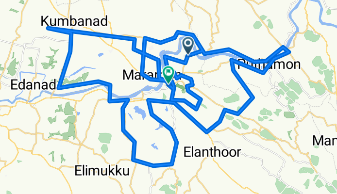
8PX8+GFP to 8PP4+F49
A cycling route starting in Pathanāmthitta, Kerala, India.
Overview
About this route
- 6 h 48 min
- Duration
- 75.2 km
- Distance
- 514 m
- Ascent
- 442 m
- Descent
- 11.1 km/h
- Avg. speed
- 56 m
- Max. altitude
Route photos


Route quality
Waytypes & surfaces along the route
Waytypes
Quiet road
36.8 km
(49 %)
Road
6 km
(8 %)
Surfaces
Paved
15 km
(20 %)
Asphalt
14.3 km
(19 %)
Paved (undefined)
0.8 km
(1 %)
Undefined
60.1 km
(80 %)
Continue with Bikemap
Use, edit, or download this cycling route
You would like to ride 8PX8+GFP to 8PP4+F49 or customize it for your own trip? Here is what you can do with this Bikemap route:
Free features
- Save this route as favorite or in collections
- Copy & plan your own version of this route
- Sync your route with Garmin or Wahoo
Premium features
Free trial for 3 days, or one-time payment. More about Bikemap Premium.
- Navigate this route on iOS & Android
- Export a GPX / KML file of this route
- Create your custom printout (try it for free)
- Download this route for offline navigation
Discover more Premium features.
Get Bikemap PremiumFrom our community
Other popular routes starting in Pathanāmthitta
 8PX8+GFP to 8PP4+F49
- Distance
- 75.2 km
- Ascent
- 514 m
- Descent
- 442 m
- Location
- Pathanāmthitta, Kerala, India
 Kozhenchery, Pathanamthitta to Kozhenchery, Pathanamthitta
- Distance
- 30 km
- Ascent
- 305 m
- Descent
- 303 m
- Location
- Pathanāmthitta, Kerala, India
 Kozhenchery, Pathanamthitta to Kozhenchery, Pathanamthitta
- Distance
- 19.4 km
- Ascent
- 226 m
- Descent
- 218 m
- Location
- Pathanāmthitta, Kerala, India
 Route to Aranmula Parthasarathy Temple
- Distance
- 63.1 km
- Ascent
- 1,628 m
- Descent
- 1,734 m
- Location
- Pathanāmthitta, Kerala, India
 Unnamed Road, Vakayar to Unnamed Road, Vakayar
- Distance
- 7.2 km
- Ascent
- 103 m
- Descent
- 104 m
- Location
- Pathanāmthitta, Kerala, India
 Kozhenchery, Pathanamthitta to Kozhenchery, Pathanamthitta
- Distance
- 30.1 km
- Ascent
- 265 m
- Descent
- 263 m
- Location
- Pathanāmthitta, Kerala, India
 Kozhenchery, Pathanamthitta to Kozhenchery, Pathanamthitta
- Distance
- 26.6 km
- Ascent
- 255 m
- Descent
- 253 m
- Location
- Pathanāmthitta, Kerala, India
 6RQ7+MVQ, Pathanamthitta to 6RQ3+PV6, Mallassery
- Distance
- 2.1 km
- Ascent
- 24 m
- Descent
- 65 m
- Location
- Pathanāmthitta, Kerala, India
Open it in the app