
22 august 2025
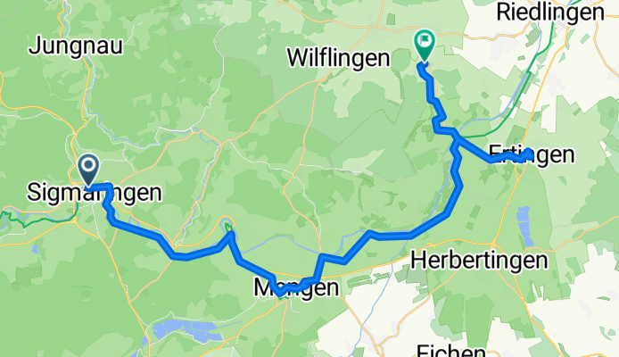
From Sigmaringen to Altheim
A cycling route starting in Sigmaringen, Baden-Wurttemberg, Germany.
Overview
About this route
- 2 h 22 min
- Duration
- 38.7 km
- Distance
- 269 m
- Ascent
- 279 m
- Descent
- 16.4 km/h
- Avg. speed
- 631 m
- Max. altitude

Part of
22 august 2025
7 stages
Route quality
Waytypes & surfaces along the route
Waytypes
Track
17.4 km
(45 %)
Quiet road
9.7 km
(25 %)
Surfaces
Paved
27.9 km
(72 %)
Unpaved
5 km
(13 %)
Asphalt
27.9 km
(72 %)
Loose gravel
2.7 km
(7 %)
Continue with Bikemap
Use, edit, or download this cycling route
You would like to ride From Sigmaringen to Altheim or customize it for your own trip? Here is what you can do with this Bikemap route:
Free features
- Save this route as favorite or in collections
- Copy & plan your own version of this route
- Sync your route with Garmin or Wahoo
Premium features
Free trial for 3 days, or one-time payment. More about Bikemap Premium.
- Navigate this route on iOS & Android
- Export a GPX / KML file of this route
- Create your custom printout (try it for free)
- Download this route for offline navigation
Discover more Premium features.
Get Bikemap PremiumFrom our community
Other popular routes starting in Sigmaringen
 Sigmaringen
- Distance
- 114.2 km
- Ascent
- 747 m
- Descent
- 757 m
- Location
- Sigmaringen, Baden-Wurttemberg, Germany
 Lange Ausfahrt vom 20. Oktober, 11:25
- Distance
- 39.8 km
- Ascent
- 80 m
- Descent
- 122 m
- Location
- Sigmaringen, Baden-Wurttemberg, Germany
 Tour 1 - Schmeiental-Tour
- Distance
- 21.6 km
- Ascent
- 375 m
- Descent
- 375 m
- Location
- Sigmaringen, Baden-Wurttemberg, Germany
 19. Sigmaringen-Riedsee/Donaueschingen (izvor Dunava)
- Distance
- 86.6 km
- Ascent
- 1,358 m
- Descent
- 1,256 m
- Location
- Sigmaringen, Baden-Wurttemberg, Germany
 Donauradweg DE 3
- Distance
- 82.6 km
- Ascent
- 277 m
- Descent
- 369 m
- Location
- Sigmaringen, Baden-Wurttemberg, Germany
 Donauradweg Siegmaringen - Riedlingen
- Distance
- 35.3 km
- Ascent
- 148 m
- Descent
- 203 m
- Location
- Sigmaringen, Baden-Wurttemberg, Germany
 UDB03_Sigmaringen-Tuttlingen
- Distance
- 57.6 km
- Ascent
- 312 m
- Descent
- 261 m
- Location
- Sigmaringen, Baden-Wurttemberg, Germany
 Tour 1 - Schmeiental-Tour
- Distance
- 19.9 km
- Ascent
- 433 m
- Descent
- 430 m
- Location
- Sigmaringen, Baden-Wurttemberg, Germany
Open it in the app