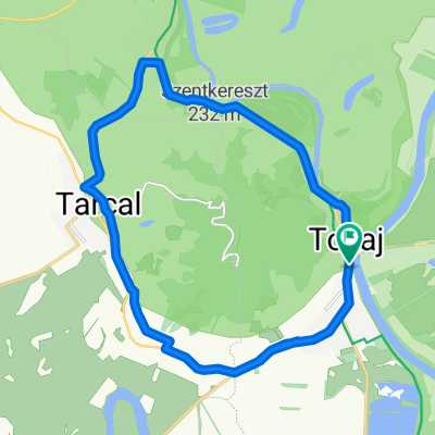
Tokaj-kor_rajzolt_20230518.gpx_1. nyomvonal
- 18.8 km
- 0 m
- 0 m
- Tokaj, Borsod-Abauj Zemplen county, Hungary
A cycling route starting in Tokaj, Borsod-Abauj Zemplen county, Hungary.
Overview
The statistics were calculated by the system based on the imported data. Distance: 18.8 km Minimum elevation: 92 m Maximum elevation: 127 m Total ascent: 71 m Total descent: 68 m
created this 3 months ago
Route quality
Cycleway
11.1 km
(59 %)
Quiet road
1.5 km
(8 %)
Paved
18.2 km
(97 %)
Asphalt
18.2 km
(97 %)
Undefined
0.6 km
(3 %)
Continue with Bikemap
You would like to ride Tokaj-kor_rajzolt_20230518.gpx_1. nyomvonal or customize it for your own trip? Here is what you can do with this Bikemap route:
Free trial for 3 days, or one-time payment. More about Bikemap Premium.
Discover more Premium features.
Get Bikemap PremiumFrom our community
Open it in the app