
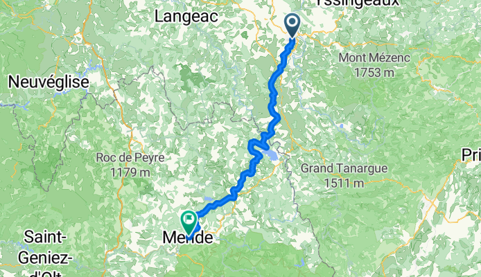
Le-Puy-Vale - Mende
A cycling route starting in Le Puy-en-Velay, Auvergne-Rhône-Alpes, France.
Overview
About this route
- -:--
- Duration
- 104.4 km
- Distance
- 1,326 m
- Ascent
- 1,185 m
- Descent
- ---
- Avg. speed
- ---
- Avg. speed
Route highlights
Points of interest along the route
Point of interest after 43.5 km
Point of interest after 43.5 km
Point of interest after 43.5 km
Continue with Bikemap
Use, edit, or download this cycling route
You would like to ride Le-Puy-Vale - Mende or customize it for your own trip? Here is what you can do with this Bikemap route:
Free features
- Save this route as favorite or in collections
- Copy & plan your own version of this route
- Sync your route with Garmin or Wahoo
Premium features
Free trial for 3 days, or one-time payment. More about Bikemap Premium.
- Navigate this route on iOS & Android
- Export a GPX / KML file of this route
- Create your custom printout (try it for free)
- Download this route for offline navigation
Discover more Premium features.
Get Bikemap PremiumFrom our community
Other popular routes starting in Le Puy-en-Velay
 Massif Central 2009 - Tour 6 - Gerbier de Jonc
- Distance
- 125.8 km
- Ascent
- 3,648 m
- Descent
- 3,649 m
- Location
- Le Puy-en-Velay, Auvergne-Rhône-Alpes, France
 2019-18 Le-Puy-en-Velay - Circle to Queyrières
- Distance
- 52.6 km
- Ascent
- 682 m
- Descent
- 681 m
- Location
- Le Puy-en-Velay, Auvergne-Rhône-Alpes, France
 Jakobsweg 2018
- Distance
- 645.1 km
- Ascent
- 2,206 m
- Descent
- 2,674 m
- Location
- Le Puy-en-Velay, Auvergne-Rhône-Alpes, France
 Jakobsweg Etappe 7 - Via Podensis : Le Puy - Decazeville
- Distance
- 226 km
- Ascent
- 2,367 m
- Descent
- 2,802 m
- Location
- Le Puy-en-Velay, Auvergne-Rhône-Alpes, France
 Tour 2010 (3)
- Distance
- 121.7 km
- Ascent
- 1,856 m
- Descent
- 1,600 m
- Location
- Le Puy-en-Velay, Auvergne-Rhône-Alpes, France
 Jakobsweg Etappe 7 - Via Podensis : Le Puy - Decazeville
- Distance
- 226 km
- Ascent
- 2,507 m
- Descent
- 2,943 m
- Location
- Le Puy-en-Velay, Auvergne-Rhône-Alpes, France
 Untitled route
- Distance
- 98.1 km
- Ascent
- 2,508 m
- Descent
- 2,095 m
- Location
- Le Puy-en-Velay, Auvergne-Rhône-Alpes, France
 Von le Puy-en-Velay - Pamblona
- Distance
- 733.5 km
- Ascent
- 8,996 m
- Descent
- 9,287 m
- Location
- Le Puy-en-Velay, Auvergne-Rhône-Alpes, France
Open it in the app