
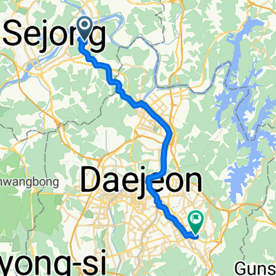
![Ph0]에서 경로연기면 548-85](https://media.bikemap.net/routes/17377894/staticmaps/in_6de7a487-78f9-4945-a307-5d4d53c3e565_694x400_bikemap-2021-3D-static.png)

보통 경로
- 14.1 km
- 588 m
- 562 m
- Songgangdong, Daejeon, South Korea
A cycling route starting in Songgangdong, Daejeon, South Korea.
Overview
created this 3 months ago
![Photo 1 of the Bikemap route "Ph0]에서 경로연기면 548-85"](https://media.bikemap.net/routes/17377894/gallery/thumbs/84958e29-1158-405d-87a8-90b28de881bb.jpg.688x400_q80_crop.jpg "Photo 1 of the Bikemap route \"Ph0]에서 경로연기면 548-85\"")
![Photo 2 of the Bikemap route "Ph0]에서 경로연기면 548-85"](https://media.bikemap.net/routes/17377894/gallery/thumbs/79b83af4-324b-4bc8-a510-4c923e67ac37.jpg.688x400_q80_crop.jpg "Photo 2 of the Bikemap route \"Ph0]에서 경로연기면 548-85\"")
![Photo 3 of the Bikemap route "Ph0]에서 경로연기면 548-85"](https://media.bikemap.net/routes/17377894/gallery/thumbs/31be2e83-7e6e-4ca5-91b4-5cb7f0917eb3.jpg.208x208_q80_crop.jpg "Photo 3 of the Bikemap route \"Ph0]에서 경로연기면 548-85\"")
![Photo 4 of the Bikemap route "Ph0]에서 경로연기면 548-85"](https://media.bikemap.net/routes/17377894/gallery/thumbs/196df0c1-1759-42d6-abda-159964a4ce10.jpg.208x208_q80_crop.jpg "Photo 4 of the Bikemap route \"Ph0]에서 경로연기면 548-85\"")
![Photo 5 of the Bikemap route "Ph0]에서 경로연기면 548-85"](https://media.bikemap.net/routes/17377894/gallery/thumbs/b88f03a5-b539-4f7a-8beb-e36aebdc6731.jpg.208x208_q80_crop.jpg "Photo 5 of the Bikemap route \"Ph0]에서 경로연기면 548-85\"")
![Photo 6 of the Bikemap route "Ph0]에서 경로연기면 548-85"](https://media.bikemap.net/routes/17377894/gallery/thumbs/1778ee12-ddaa-49b1-9c10-bd7468b15983.jpg.208x208_q80_crop.jpg "Photo 6 of the Bikemap route \"Ph0]에서 경로연기면 548-85\"")
![Photo 7 of the Bikemap route "Ph0]에서 경로연기면 548-85"](https://media.bikemap.net/routes/17377894/gallery/thumbs/7418cba5-fa41-4b76-8dfa-836c5c9097ff.jpg.208x208_q80_crop.jpg "Photo 7 of the Bikemap route \"Ph0]에서 경로연기면 548-85\"")
Continue with Bikemap
You would like to ride Ph0]에서 경로연기면 548-85 or customize it for your own trip? Here is what you can do with this Bikemap route:
Free trial for 3 days, or one-time payment. More about Bikemap Premium.
Discover more Premium features.
Get Bikemap PremiumFrom our community
Open it in the app


![Ph0]에서 경로연기면 548-85](https://media.bikemap.net/routes/17377894/gallery/thumbs/84958e29-1158-405d-87a8-90b28de881bb.jpg.208x208_q80_crop.jpg)