
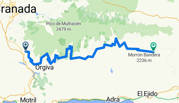
Overview
About this route
- 7 h 24 min
- Duration
- 118.4 km
- Distance
- 989 m
- Ascent
- 1,509 m
- Descent
- 16 km/h
- Avg. speed
- 1,646 m
- Max. altitude
Part of
Transandalus
17 stages
Continue with Bikemap
Use, edit, or download this cycling route
You would like to ride Nigüelas - Padules or customize it for your own trip? Here is what you can do with this Bikemap route:
Free features
- Save this route as favorite or in collections
- Copy & plan your own version of this route
- Split it into stages to create a multi-day tour
- Sync your route with Garmin or Wahoo
Premium features
Free trial for 3 days, or one-time payment. More about Bikemap Premium.
- Navigate this route on iOS & Android
- Export a GPX / KML file of this route
- Create your custom printout (try it for free)
- Download this route for offline navigation
Discover more Premium features.
Get Bikemap PremiumFrom our community
Other popular routes starting in Nigüelas
 Nigüelas - Loma de los tres mojones
- Distance
- 48.4 km
- Ascent
- 1,587 m
- Descent
- 1,584 m
- Location
- Nigüelas, Andalusia, Spain
 INTEGRAL SIERRA NEVADA
- Distance
- 67.6 km
- Ascent
- 3,121 m
- Descent
- 4,105 m
- Location
- Nigüelas, Andalusia, Spain
 GR417-Nigüelas-La Giralda-Albuñuelas 05-10-2013
- Distance
- 56.5 km
- Ascent
- 1,305 m
- Descent
- 1,305 m
- Location
- Nigüelas, Andalusia, Spain
 Nigüelas - La Rinconada
- Distance
- 28.9 km
- Ascent
- 1,288 m
- Descent
- 1,287 m
- Location
- Nigüelas, Andalusia, Spain
 Nigüelas - Padules
- Distance
- 118.4 km
- Ascent
- 989 m
- Descent
- 1,509 m
- Location
- Nigüelas, Andalusia, Spain
 Nigüelas - río Torrente
- Distance
- 30.9 km
- Ascent
- 1,276 m
- Descent
- 1,273 m
- Location
- Nigüelas, Andalusia, Spain
 121226 melegis-alhamadegranada
- Distance
- 59 km
- Ascent
- 1,112 m
- Descent
- 887 m
- Location
- Nigüelas, Andalusia, Spain
 Niguelas
- Distance
- 7.5 km
- Ascent
- 562 m
- Descent
- 385 m
- Location
- Nigüelas, Andalusia, Spain
Open it in the app