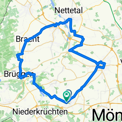
Karrenweg nach Luisenstraße
A cycling route starting in Schwalmtal, North Rhine-Westphalia, Germany.
Overview
About this route
- 43 min
- Duration
- 9.6 km
- Distance
- 6 m
- Ascent
- 66 m
- Descent
- 13.5 km/h
- Avg. speed
- 120 m
- Max. altitude
Route photos
Route quality
Waytypes & surfaces along the route
Waytypes
- Path - 3.7 km - (39 %) 
- Quiet road - 2.8 km - (29 %) 
Surfaces
Paved
2.7 km
(28 %)
Unpaved
1.6 km
(17 %)
- Asphalt - 2 km - (21 %) 
- Gravel - 1 km - (10 %) 
Continue with Bikemap
Use, edit, or download this cycling route
You would like to ride Karrenweg nach Luisenstraße or customize it for your own trip? Here is what you can do with this Bikemap route:
Free features
- Save this route as favorite or in collections
- Copy & plan your own version of this route
- Sync your route with Garmin or Wahoo
Premium features
Free trial for 3 days, or one-time payment. More about Bikemap Premium.
- Navigate this route on iOS & Android
- Export a GPX / KML file of this route
- Create your custom printout (try it for free)
- Download this route for offline navigation
Discover more Premium features.
Get Bikemap PremiumFrom our community
Other popular routes starting in Schwalmtal
 ROUTE 60 Familienroute ROUTE 60 Familienroute- Distance
- 28.8 km
- Ascent
- 91 m
- Descent
- 89 m
- Location
- Schwalmtal, North Rhine-Westphalia, Germany
 
 Karrenweg nach Luisenstraße Karrenweg nach Luisenstraße- Distance
- 9.6 km
- Ascent
- 6 m
- Descent
- 66 m
- Location
- Schwalmtal, North Rhine-Westphalia, Germany
 
 Rickelrath Hardter Wald Rickelrath Hardter Wald- Distance
- 19.5 km
- Ascent
- 76 m
- Descent
- 74 m
- Location
- Schwalmtal, North Rhine-Westphalia, Germany
 
 H 43,8 - wegB.- rotenB.-cafeB.-H H 43,8 - wegB.- rotenB.-cafeB.-H- Distance
- 43.8 km
- Ascent
- 149 m
- Descent
- 147 m
- Location
- Schwalmtal, North Rhine-Westphalia, Germany
 
 Waldniel Rothenbach 45 km Waldniel Rothenbach 45 km- Distance
- 45.7 km
- Ascent
- 163 m
- Descent
- 163 m
- Location
- Schwalmtal, North Rhine-Westphalia, Germany
 
 RTFSchwalmtal-Waldniel 70km-Runde RTFSchwalmtal-Waldniel 70km-Runde- Distance
- 70.1 km
- Ascent
- 182 m
- Descent
- 189 m
- Location
- Schwalmtal, North Rhine-Westphalia, Germany
 
 O 77 Brügg-Depot-Reuver-Buggen-Roerm-Oberkr-Hardt O 77 Brügg-Depot-Reuver-Buggen-Roerm-Oberkr-Hardt- Distance
- 76.7 km
- Ascent
- 176 m
- Descent
- 176 m
- Location
- Schwalmtal, North Rhine-Westphalia, Germany
 
 Hardter Wald1 Hardter Wald1- Distance
- 10.7 km
- Ascent
- 31 m
- Descent
- 31 m
- Location
- Schwalmtal, North Rhine-Westphalia, Germany
 
Open it in the app


