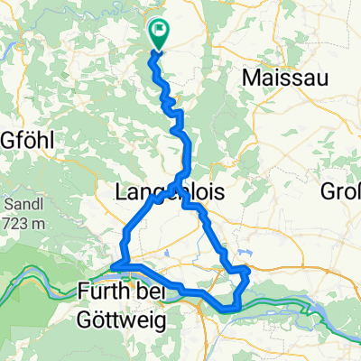
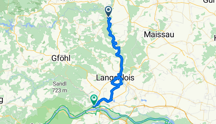
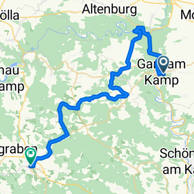
Kamptalweg Abschnitt D, Gars am Kamp nach Bahnhofplatz, Krems an der Donau
A cycling route starting in Gars am Kamp, Lower Austria, Austria.
Overview
About this route
- 3 h 52 min
- Duration
- 50 km
- Distance
- 474 m
- Ascent
- 548 m
- Descent
- 12.9 km/h
- Avg. speed
- 286 m
- Max. altitude
Route photos
Route quality
Waytypes & surfaces along the route
Waytypes
Quiet road
21.5 km
(43 %)
Track
12.9 km
(26 %)
Surfaces
Paved
32 km
(64 %)
Unpaved
5.9 km
(12 %)
Asphalt
30.1 km
(60 %)
Gravel
5.8 km
(12 %)
Continue with Bikemap
Use, edit, or download this cycling route
You would like to ride Kamptalweg Abschnitt D, Gars am Kamp nach Bahnhofplatz, Krems an der Donau or customize it for your own trip? Here is what you can do with this Bikemap route:
Free features
- Save this route as favorite or in collections
- Copy & plan your own version of this route
- Sync your route with Garmin or Wahoo
Premium features
Free trial for 3 days, or one-time payment. More about Bikemap Premium.
- Navigate this route on iOS & Android
- Export a GPX / KML file of this route
- Create your custom printout (try it for free)
- Download this route for offline navigation
Discover more Premium features.
Get Bikemap PremiumFrom our community
Other popular routes starting in Gars am Kamp
- Stupa Irene 1
- Distance
- 90.1 km
- Ascent
- 340 m
- Descent
- 418 m
- Location
- Gars am Kamp, Lower Austria, Austria
- Von Gars am Kamp nach Schönberg am Kamp
- Distance
- 14.4 km
- Ascent
- 256 m
- Descent
- 287 m
- Location
- Gars am Kamp, Lower Austria, Austria
- Ausfahrt von Stallegg nach Langenlois
- Distance
- 25.7 km
- Ascent
- 167 m
- Descent
- 225 m
- Location
- Gars am Kamp, Lower Austria, Austria
- Kamptalweg Abschnitt D, Gars am Kamp nach Bahnhofplatz, Krems an der Donau
- Distance
- 50 km
- Ascent
- 474 m
- Descent
- 548 m
- Location
- Gars am Kamp, Lower Austria, Austria
- 15.05.2022
- Distance
- 46.9 km
- Ascent
- 369 m
- Descent
- 371 m
- Location
- Gars am Kamp, Lower Austria, Austria
- Gars-Rosenburg-Tautendorf-Stiefern-
- Distance
- 36.6 km
- Ascent
- 446 m
- Descent
- 446 m
- Location
- Gars am Kamp, Lower Austria, Austria
- kleine Kamptalrunde
- Distance
- 29.2 km
- Ascent
- 408 m
- Descent
- 409 m
- Location
- Gars am Kamp, Lower Austria, Austria
- Graslweg
- Distance
- 39.2 km
- Ascent
- 488 m
- Descent
- 489 m
- Location
- Gars am Kamp, Lower Austria, Austria
Open it in the app