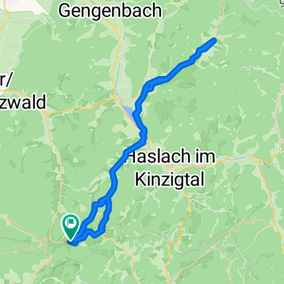
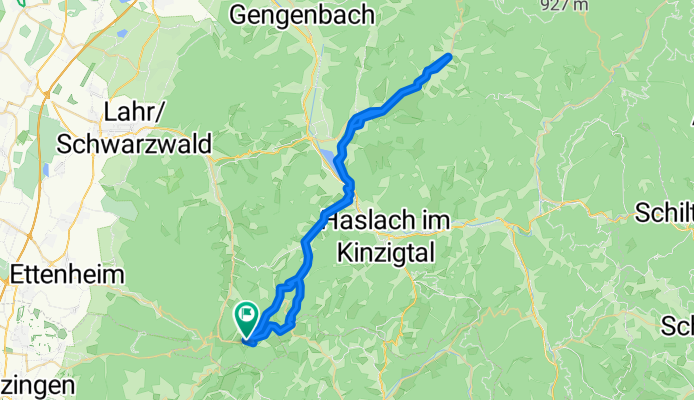
Gartenstraße nach Gartenstraße
A cycling route starting in Schuttertal, Baden-Wurttemberg, Germany.
Overview
About this route
- 3 h 4 min
- Duration
- 57.2 km
- Distance
- 847 m
- Ascent
- 898 m
- Descent
- 18.7 km/h
- Avg. speed
- 668 m
- Max. altitude
Route quality
Waytypes & surfaces along the route
Waytypes
Quiet road
10.9 km
(19 %)
Pedestrian area
8.6 km
(15 %)
Surfaces
Paved
49.8 km
(87 %)
Unpaved
4 km
(7 %)
Asphalt
43.5 km
(76 %)
Paved (undefined)
6.3 km
(11 %)
Continue with Bikemap
Use, edit, or download this cycling route
You would like to ride Gartenstraße nach Gartenstraße or customize it for your own trip? Here is what you can do with this Bikemap route:
Free features
- Save this route as favorite or in collections
- Copy & plan your own version of this route
- Sync your route with Garmin or Wahoo
Premium features
Free trial for 3 days, or one-time payment. More about Bikemap Premium.
- Navigate this route on iOS & Android
- Export a GPX / KML file of this route
- Create your custom printout (try it for free)
- Download this route for offline navigation
Discover more Premium features.
Get Bikemap PremiumFrom our community
Other popular routes starting in Schuttertal
Gartenstraße nach Gartenstraße- Distance
- 39.4 km
- Ascent
- 700 m
- Descent
- 752 m
- Location
- Schuttertal, Baden-Wurttemberg, Germany
Im Wolfersbach - Schweighausen - Steinach - Biberach - Seelbach- Distance
- 43.1 km
- Ascent
- 826 m
- Descent
- 887 m
- Location
- Schuttertal, Baden-Wurttemberg, Germany
Schuttertal GA1- Distance
- 26.9 km
- Ascent
- 518 m
- Descent
- 516 m
- Location
- Schuttertal, Baden-Wurttemberg, Germany
Waldkirch- Distance
- 26.8 km
- Ascent
- 472 m
- Descent
- 632 m
- Location
- Schuttertal, Baden-Wurttemberg, Germany
Schwarzwald Quer Schuttertal-Schramberg- Distance
- 62.5 km
- Ascent
- 2,348 m
- Descent
- 1,912 m
- Location
- Schuttertal, Baden-Wurttemberg, Germany
Wahnsinnsfahrt- Distance
- 42.2 km
- Ascent
- 549 m
- Descent
- 590 m
- Location
- Schuttertal, Baden-Wurttemberg, Germany
Gartenstraße nach Gartenstraße- Distance
- 57.2 km
- Ascent
- 847 m
- Descent
- 898 m
- Location
- Schuttertal, Baden-Wurttemberg, Germany
Weg zur Downhillstrecke von Welschensteinach aus- Distance
- 0.8 km
- Ascent
- 157 m
- Descent
- 0 m
- Location
- Schuttertal, Baden-Wurttemberg, Germany
Open it in the app


