

Lehká trasa,po hrázi dolního a prostředního jezera
A cycling route starting in Šakvice, South Moravian, Czechia.
Overview
About this route
The more information you write here, the more useful it will be for other users.* Route details.* What is special about this route?* Why recommend this route?* What did you like most about this place?* Etc.
- -:--
- Duration
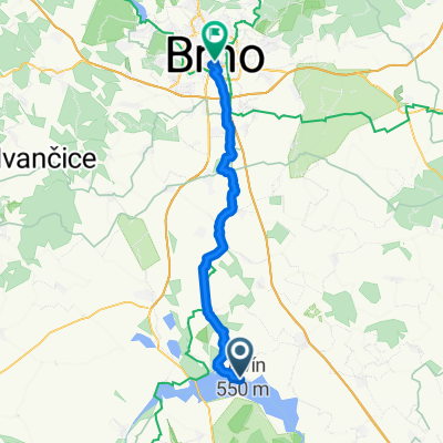
- 37.7 km
- Distance
- 117 m
- Ascent
- 181 m
- Descent
- ---
- Avg. speed
- 247 m
- Max. altitude

Route quality
Waytypes & surfaces along the route
Waytypes
Track
15.8 km
(42 %)
Road
9 km
(24 %)
Surfaces
Paved
29.8 km
(79 %)
Unpaved
4.5 km
(12 %)
Asphalt
23.4 km
(62 %)
Concrete
6 km
(16 %)
Continue with Bikemap
Use, edit, or download this cycling route
You would like to ride Lehká trasa,po hrázi dolního a prostředního jezera or customize it for your own trip? Here is what you can do with this Bikemap route:
Free features
- Save this route as favorite or in collections
- Copy & plan your own version of this route
- Sync your route with Garmin or Wahoo
Premium features
Free trial for 3 days, or one-time payment. More about Bikemap Premium.
- Navigate this route on iOS & Android
- Export a GPX / KML file of this route
- Create your custom printout (try it for free)
- Download this route for offline navigation
Discover more Premium features.
Get Bikemap PremiumFrom our community
Other popular routes starting in Šakvice
 Sakvice to Mikulov
- Distance
- 32.7 km
- Ascent
- 395 m
- Descent
- 355 m
- Location
- Šakvice, South Moravian, Czechia
 1397/26
- Distance
- 44.8 km
- Ascent
- 142 m
- Descent
- 143 m
- Location
- Šakvice, South Moravian, Czechia
 Popice - Milovice - Bulhary - Lednice - Rakvice - Milovice - Popice
- Distance
- 58.2 km
- Ascent
- 223 m
- Descent
- 230 m
- Location
- Šakvice, South Moravian, Czechia
 Popice nach Znojmo
- Distance
- 77.8 km
- Ascent
- 396 m
- Descent
- 269 m
- Location
- Šakvice, South Moravian, Czechia
 Lehká trasa,po hrázi dolního a prostředního jezera
- Distance
- 37.7 km
- Ascent
- 117 m
- Descent
- 181 m
- Location
- Šakvice, South Moravian, Czechia
 Pálava 2012 - den první
- Distance
- 55.8 km
- Ascent
- 261 m
- Descent
- 261 m
- Location
- Šakvice, South Moravian, Czechia
 Dalibor-Maják-Minaret
- Distance
- 48.7 km
- Ascent
- 209 m
- Descent
- 224 m
- Location
- Šakvice, South Moravian, Czechia
 Palavská nach Brno
- Distance
- 42.1 km
- Ascent
- 143 m
- Descent
- 97 m
- Location
- Šakvice, South Moravian, Czechia
Open it in the app