
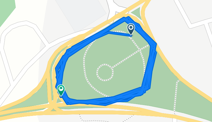
De BR-308 a BR-308
A cycling route starting in Capanema, Pará, Brazil.
Overview
About this route
- 1 h 5 min
- Duration
- 5.1 km
- Distance
- 95 m
- Ascent
- 66 m
- Descent
- 4.7 km/h
- Avg. speed
- 31 m
- Max. altitude
Route photos


Continue with Bikemap
Use, edit, or download this cycling route
You would like to ride De BR-308 a BR-308 or customize it for your own trip? Here is what you can do with this Bikemap route:
Free features
- Save this route as favorite or in collections
- Copy & plan your own version of this route
- Sync your route with Garmin or Wahoo
Premium features
Free trial for 3 days, or one-time payment. More about Bikemap Premium.
- Navigate this route on iOS & Android
- Export a GPX / KML file of this route
- Create your custom printout (try it for free)
- Download this route for offline navigation
Discover more Premium features.
Get Bikemap PremiumFrom our community
Other popular routes starting in Capanema
 Travessa Bom Jardim, 588, Capanema a Travessa Bom Jardim, 590, Capanema
- Distance
- 7.4 km
- Ascent
- 36 m
- Descent
- 36 m
- Location
- Capanema, Pará, Brazil
 Cavalgada estável
- Distance
- 9.9 km
- Ascent
- 57 m
- Descent
- 64 m
- Location
- Capanema, Pará, Brazil
 Rota via Tauari
- Distance
- 60.1 km
- Ascent
- 511 m
- Descent
- 531 m
- Location
- Capanema, Pará, Brazil
 trilha de tauari
- Distance
- 34.4 km
- Ascent
- 485 m
- Descent
- 477 m
- Location
- Capanema, Pará, Brazil
 De Travessa Veiga Cabral 207 a Tv. PRF
- Distance
- 44.9 km
- Ascent
- 236 m
- Descent
- 213 m
- Location
- Capanema, Pará, Brazil
 De BR-308 a BR-308
- Distance
- 5.1 km
- Ascent
- 95 m
- Descent
- 66 m
- Location
- Capanema, Pará, Brazil
 trilha de ajuruteua
- Distance
- 100.5 km
- Ascent
- 2,794 m
- Descent
- 2,812 m
- Location
- Capanema, Pará, Brazil
 capanema
- Distance
- 13.2 km
- Ascent
- 82 m
- Descent
- 61 m
- Location
- Capanema, Pará, Brazil
Open it in the app