
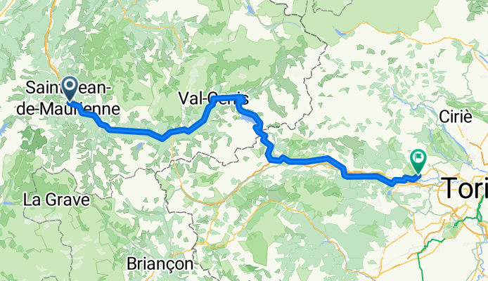
Maurienne_Torino
A cycling route starting in Saint-Jean-de-Maurienne, Auvergne-Rhône-Alpes, France.
Overview
About this route
- 7 h 35 min
- Duration
- 144.2 km
- Distance
- 3,062 m
- Ascent
- 3,288 m
- Descent
- 19 km/h
- Avg. speed
- 2,095 m
- Max. altitude

Route quality
Waytypes & surfaces along the route
Waytypes
Quiet road
34.6 km
(24 %)
Road
21.6 km
(15 %)
Surfaces
Paved
128.3 km
(89 %)
Asphalt
128.3 km
(89 %)
Undefined
15.9 km
(11 %)
Continue with Bikemap
Use, edit, or download this cycling route
You would like to ride Maurienne_Torino or customize it for your own trip? Here is what you can do with this Bikemap route:
Free features
- Save this route as favorite or in collections
- Copy & plan your own version of this route
- Split it into stages to create a multi-day tour
- Sync your route with Garmin or Wahoo
Premium features
Free trial for 3 days, or one-time payment. More about Bikemap Premium.
- Navigate this route on iOS & Android
- Export a GPX / KML file of this route
- Create your custom printout (try it for free)
- Download this route for offline navigation
Discover more Premium features.
Get Bikemap PremiumFrom our community
Other popular routes starting in Saint-Jean-de-Maurienne
 Maurienne - J3 Bis
- Distance
- 165.7 km
- Ascent
- 3,339 m
- Descent
- 3,340 m
- Location
- Saint-Jean-de-Maurienne, Auvergne-Rhône-Alpes, France
 Col de la Croix de Fer- Col du Glandon
- Distance
- 62.3 km
- Ascent
- 1,665 m
- Descent
- 1,665 m
- Location
- Saint-Jean-de-Maurienne, Auvergne-Rhône-Alpes, France
 la montée à LA TOUSSUIRE
- Distance
- 33.9 km
- Ascent
- 1,172 m
- Descent
- 1,173 m
- Location
- Saint-Jean-de-Maurienne, Auvergne-Rhône-Alpes, France
 montée oullaz par jarrier 002
- Distance
- 12.8 km
- Ascent
- 1,016 m
- Descent
- 30 m
- Location
- Saint-Jean-de-Maurienne, Auvergne-Rhône-Alpes, France
 St Jean de Maurienne - Galibier - Croix de Fer - St J
- Distance
- 161.4 km
- Ascent
- 3,453 m
- Descent
- 3,453 m
- Location
- Saint-Jean-de-Maurienne, Auvergne-Rhône-Alpes, France
 Maurienne - J3
- Distance
- 164.2 km
- Ascent
- 3,430 m
- Descent
- 3,429 m
- Location
- Saint-Jean-de-Maurienne, Auvergne-Rhône-Alpes, France
 Subidas a los Cols de Glandon-Croix de Fer y de la Madeleine
- Distance
- 132.6 km
- Ascent
- 3,278 m
- Descent
- 3,285 m
- Location
- Saint-Jean-de-Maurienne, Auvergne-Rhône-Alpes, France
 020 - 2014
- Distance
- 71.8 km
- Ascent
- 1,404 m
- Descent
- 178 m
- Location
- Saint-Jean-de-Maurienne, Auvergne-Rhône-Alpes, France
Open it in the app