
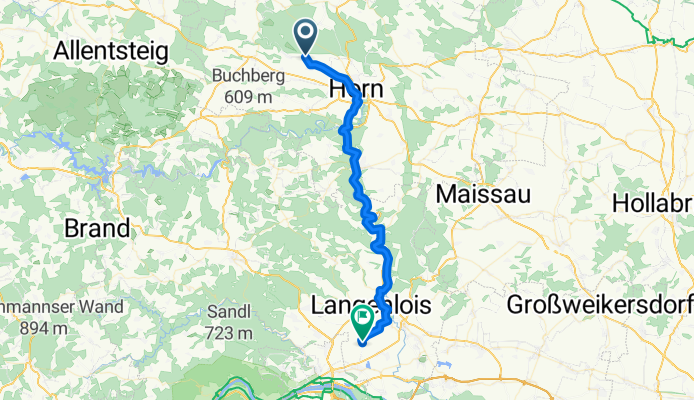
From Prague to Vienna
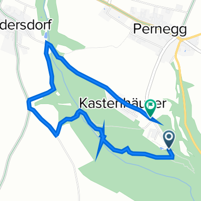
Pernegg - Gedersdorf
A cycling route starting in Pernegg, Lower Austria, Austria.
Overview
About this route
- 2 h 45 min
- Duration
- 43.1 km
- Distance
- 594 m
- Ascent
- 667 m
- Descent
- 15.7 km/h
- Avg. speed
- 352 m
- Max. altitude

Part of
From Prague to Vienna
9 stages
Route quality
Waytypes & surfaces along the route
Waytypes
Quiet road
16 km
(37 %)
Track
15.1 km
(35 %)
Surfaces
Paved
27.6 km
(64 %)
Unpaved
5.2 km
(12 %)
Asphalt
26.7 km
(62 %)
Gravel
5.2 km
(12 %)
Continue with Bikemap
Use, edit, or download this cycling route
You would like to ride Pernegg - Gedersdorf or customize it for your own trip? Here is what you can do with this Bikemap route:
Free features
- Save this route as favorite or in collections
- Copy & plan your own version of this route
- Sync your route with Garmin or Wahoo
Premium features
Free trial for 3 days, or one-time payment. More about Bikemap Premium.
- Navigate this route on iOS & Android
- Export a GPX / KML file of this route
- Create your custom printout (try it for free)
- Download this route for offline navigation
Discover more Premium features.
Get Bikemap PremiumFrom our community
Other popular routes starting in Pernegg
 Pernegg - Schrattenthal - Rodingersdorf - Pernegg
- Distance
- 100.8 km
- Ascent
- 605 m
- Descent
- 601 m
- Location
- Pernegg, Lower Austria, Austria
 Krems-Kamptal-Start-Hötzelsdorf
- Distance
- 53.6 km
- Ascent
- 351 m
- Descent
- 628 m
- Location
- Pernegg, Lower Austria, Austria
 Gallien - Hollabrunn
- Distance
- 45.8 km
- Ascent
- 178 m
- Descent
- 359 m
- Location
- Pernegg, Lower Austria, Austria
 retz
retz- Distance
- 27.2 km
- Ascent
- 206 m
- Descent
- 426 m
- Location
- Pernegg, Lower Austria, Austria
 Pernegg Weg der Stille
- Distance
- 3.5 km
- Ascent
- 254 m
- Descent
- 231 m
- Location
- Pernegg, Lower Austria, Austria
 Hötzelsdorf-Krems
- Distance
- 53.6 km
- Ascent
- 322 m
- Descent
- 619 m
- Location
- Pernegg, Lower Austria, Austria
 Radtour Waldviertel
- Distance
- 55.4 km
- Ascent
- 435 m
- Descent
- 437 m
- Location
- Pernegg, Lower Austria, Austria
 Gallien - Stiefern
- Distance
- 31.3 km
- Ascent
- 231 m
- Descent
- 403 m
- Location
- Pernegg, Lower Austria, Austria
Open it in the app