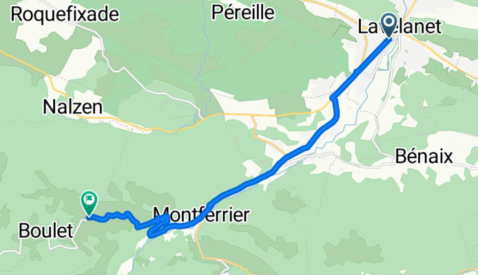
COL DE LA LAUZE (por Lavelanet)
A cycling route starting in Lavelanet, Languedoc-Roussillon-Midi-Pyrénées, France.
Overview
About this route
El Col de la Lauze (944 m), en la región de Ariège (Pirineos franceses), es un paso corto y modesto en comparación con otros grandes colosos pirenaicos, pero con encanto cicloturista. Se sitúa muy cerca del Col de Montségur, por lo que suele enlazarse en rutas ciclistas locales y travesías de media montaña
- 43 min
- Duration
- 11 km
- Distance
- 485 m
- Ascent
- 69 m
- Descent
- 15.3 km/h
- Avg. speed
- 951 m
- Max. altitude
Route photos
Route quality
Waytypes & surfaces along the route
Waytypes
Road
4.3 km
(39 %)
Quiet road
0.6 km
(6 %)
Surfaces
Paved
0.4 km
(4 %)
Asphalt
0.4 km
(4 %)
Undefined
10.6 km
(96 %)
Continue with Bikemap
Use, edit, or download this cycling route
You would like to ride COL DE LA LAUZE (por Lavelanet) or customize it for your own trip? Here is what you can do with this Bikemap route:
Free features
- Save this route as favorite or in collections
- Copy & plan your own version of this route
- Sync your route with Garmin or Wahoo
Premium features
Free trial for 3 days, or one-time payment. More about Bikemap Premium.
- Navigate this route on iOS & Android
- Export a GPX / KML file of this route
- Create your custom printout (try it for free)
- Download this route for offline navigation
Discover more Premium features.
Get Bikemap PremiumFrom our community
Other popular routes starting in Lavelanet
- Lavelanet-Boucle 68Km
- Distance
- 67.8 km
- Ascent
- 546 m
- Descent
- 546 m
- Location
- Lavelanet, Languedoc-Roussillon-Midi-Pyrénées, France
- Retour Lavalenet
- Distance
- 33.7 km
- Ascent
- 224 m
- Descent
- 441 m
- Location
- Lavelanet, Languedoc-Roussillon-Midi-Pyrénées, France
- F/Villeneuve-Espezel-Montsegur-ret
- Distance
- 88.1 km
- Ascent
- 1,292 m
- Descent
- 1,293 m
- Location
- Lavelanet, Languedoc-Roussillon-Midi-Pyrénées, France
- brm2
- Distance
- 118.9 km
- Ascent
- 997 m
- Descent
- 1,602 m
- Location
- Lavelanet, Languedoc-Roussillon-Midi-Pyrénées, France
- Montsegur a Brindisi
- Distance
- 3,190.5 km
- Ascent
- 7,935 m
- Descent
- 8,840 m
- Location
- Lavelanet, Languedoc-Roussillon-Midi-Pyrénées, France
- Pyrenäen 2000 Etappe 15
- Distance
- 87 km
- Ascent
- 1,042 m
- Descent
- 1,416 m
- Location
- Lavelanet, Languedoc-Roussillon-Midi-Pyrénées, France
- ddsdq
- Distance
- 20 km
- Ascent
- 186 m
- Descent
- 255 m
- Location
- Lavelanet, Languedoc-Roussillon-Midi-Pyrénées, France
- CC Etapa 03 MONTSÉGUR a PUIVERT
- Distance
- 47 km
- Ascent
- 573 m
- Descent
- 889 m
- Location
- Lavelanet, Languedoc-Roussillon-Midi-Pyrénées, France
Open it in the app