
Von Uitikon Waldegg bis les Imberts
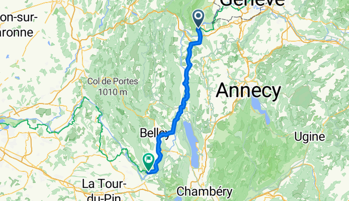
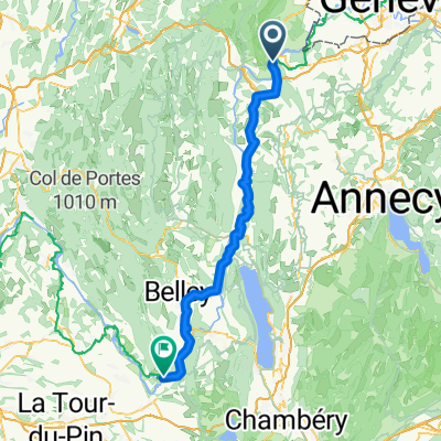
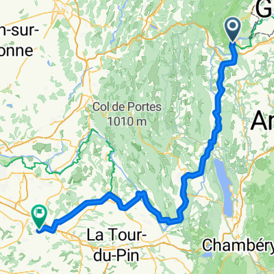
Collonges - Saint-Genix-sur-Guiers
A cycling route starting in Collonges, Auvergne-Rhône-Alpes, France.
Overview
About this route
- 4 h 21 min
- Duration
- 76.6 km
- Distance
- 577 m
- Ascent
- 800 m
- Descent
- 17.6 km/h
- Avg. speed
- 574 m
- Max. altitude
Part of
Von Uitikon Waldegg bis les Imberts
11 stages
Route quality
Waytypes & surfaces along the route
Waytypes
Cycleway
29.9 km
(39 %)
Quiet road
16.1 km
(21 %)
Surfaces
Paved
52.8 km
(69 %)
Asphalt
49.8 km
(65 %)
Paved (undefined)
3.1 km
(4 %)
Undefined
23.7 km
(31 %)
Continue with Bikemap
Use, edit, or download this cycling route
You would like to ride Collonges - Saint-Genix-sur-Guiers or customize it for your own trip? Here is what you can do with this Bikemap route:
Free features
- Save this route as favorite or in collections
- Copy & plan your own version of this route
- Sync your route with Garmin or Wahoo
Premium features
Free trial for 3 days, or one-time payment. More about Bikemap Premium.
- Navigate this route on iOS & Android
- Export a GPX / KML file of this route
- Create your custom printout (try it for free)
- Download this route for offline navigation
Discover more Premium features.
Get Bikemap PremiumFrom our community
Other popular routes starting in Collonges
 Rue du Fort 218, Collonges nach Rue de la Mairie 22, Culoz
- Distance
- 48.6 km
- Ascent
- 612 m
- Descent
- 860 m
- Location
- Collonges, Auvergne-Rhône-Alpes, France
 Collonges - Burtigny (Jura)
- Distance
- 110.1 km
- Ascent
- 2,213 m
- Descent
- 1,608 m
- Location
- Collonges, Auvergne-Rhône-Alpes, France
 Rue du Fort 218, Collonges nach Route du Bois-des-Frères 40, Le Lignon
- Distance
- 27.5 km
- Ascent
- 229 m
- Descent
- 311 m
- Location
- Collonges, Auvergne-Rhône-Alpes, France
 von Genf nach Lyon - Tag 2 - von Collonges nach Seyssel
- Distance
- 32 km
- Ascent
- 535 m
- Descent
- 778 m
- Location
- Collonges, Auvergne-Rhône-Alpes, France
 Wielka Wyprawa 09
- Distance
- 300 km
- Ascent
- 1,339 m
- Descent
- 1,684 m
- Location
- Collonges, Auvergne-Rhône-Alpes, France
 Collonges - Saint-Genix-sur-Guiers
- Distance
- 76.6 km
- Ascent
- 577 m
- Descent
- 800 m
- Location
- Collonges, Auvergne-Rhône-Alpes, France
 st ju poezat
- Distance
- 284.5 km
- Ascent
- 2,951 m
- Descent
- 3,014 m
- Location
- Collonges, Auvergne-Rhône-Alpes, France
 Collonges - Villefontaine
- Distance
- 138.9 km
- Ascent
- 997 m
- Descent
- 1,137 m
- Location
- Collonges, Auvergne-Rhône-Alpes, France
Open it in the app