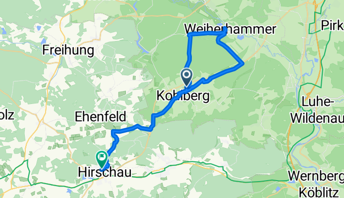
Von Kohlberg über Weiherhammer bis Hirschau
A cycling route starting in Kohlberg, Bavaria, Germany.
Overview
About this route
- 1 h 45 min
- Duration
- 27.3 km
- Distance
- 311 m
- Ascent
- 346 m
- Descent
- 15.6 km/h
- Avg. speed
- 527 m
- Max. altitude
Route photos
Route quality
Waytypes & surfaces along the route
Waytypes
Track
12.9 km
(47 %)
Quiet road
9.1 km
(33 %)
Surfaces
Paved
18.1 km
(66 %)
Unpaved
6.3 km
(23 %)
Asphalt
18.1 km
(66 %)
Gravel
6.3 km
(23 %)
Continue with Bikemap
Use, edit, or download this cycling route
You would like to ride Von Kohlberg über Weiherhammer bis Hirschau or customize it for your own trip? Here is what you can do with this Bikemap route:
Free features
- Save this route as favorite or in collections
- Copy & plan your own version of this route
- Sync your route with Garmin or Wahoo
Premium features
Free trial for 3 days, or one-time payment. More about Bikemap Premium.
- Navigate this route on iOS & Android
- Export a GPX / KML file of this route
- Create your custom printout (try it for free)
- Download this route for offline navigation
Discover more Premium features.
Get Bikemap PremiumFrom our community
Other popular routes starting in Kohlberg
- freihung
- Distance
- 2.6 km
- Ascent
- 47 m
- Descent
- 0 m
- Location
- Kohlberg, Bavaria, Germany
- Mike I
- Distance
- 35.2 km
- Ascent
- 270 m
- Descent
- 270 m
- Location
- Kohlberg, Bavaria, Germany
- Röthenbach - Freihung
- Distance
- 9.1 km
- Ascent
- 151 m
- Descent
- 147 m
- Location
- Kohlberg, Bavaria, Germany
- Rödlas 4, Hirschau nach Karl-Hofbauer-Straße 2, Altenstadt an der Waldnaab
- Distance
- 83.4 km
- Ascent
- 290 m
- Descent
- 412 m
- Location
- Kohlberg, Bavaria, Germany
- Route to Badstraße 13, Schnaittenbach
- Distance
- 8.6 km
- Ascent
- 145 m
- Descent
- 153 m
- Location
- Kohlberg, Bavaria, Germany
- Rund um Kohlberg I
- Distance
- 24.4 km
- Ascent
- 345 m
- Descent
- 345 m
- Location
- Kohlberg, Bavaria, Germany
- Von Kohlberg über Weiherhammer bis Hirschau
- Distance
- 27.3 km
- Ascent
- 311 m
- Descent
- 346 m
- Location
- Kohlberg, Bavaria, Germany
- Marktplatz 1, Kohlberg nach Georgenstraße 2, Amberg
- Distance
- 28 km
- Ascent
- 312 m
- Descent
- 417 m
- Location
- Kohlberg, Bavaria, Germany
Open it in the app