
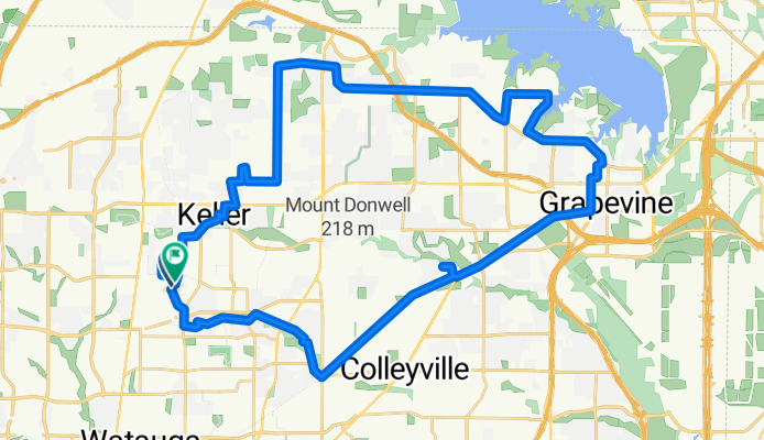
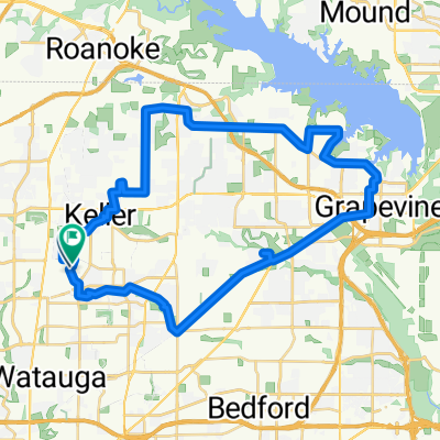
Dale Court to Dale Court
A cycling route starting in Keller, Texas, United States.
Overview
About this route
- 2 h 23 min
- Duration
- 54.8 km
- Distance
- 279 m
- Ascent
- 239 m
- Descent
- 23.1 km/h
- Avg. speed
- 242 m
- Max. altitude
Route quality
Waytypes & surfaces along the route
Waytypes
Cycleway
23 km
(42 %)
Road
8.2 km
(15 %)
Surfaces
Paved
24.7 km
(45 %)
Concrete
19.7 km
(36 %)
Asphalt
3.8 km
(7 %)
Continue with Bikemap
Use, edit, or download this cycling route
You would like to ride Dale Court to Dale Court or customize it for your own trip? Here is what you can do with this Bikemap route:
Free features
- Save this route as favorite or in collections
- Copy & plan your own version of this route
- Sync your route with Garmin or Wahoo
Premium features
Free trial for 3 days, or one-time payment. More about Bikemap Premium.
- Navigate this route on iOS & Android
- Export a GPX / KML file of this route
- Create your custom printout (try it for free)
- Download this route for offline navigation
Discover more Premium features.
Get Bikemap PremiumFrom our community
Other popular routes starting in Keller
 Continental Trail 7401, Fort Worth to Briar Meadow Court 701, Keller
- Distance
- 16.8 km
- Ascent
- 97 m
- Descent
- 93 m
- Location
- Keller, Texas, United States
 Dale Court to Dale Court
- Distance
- 54.8 km
- Ascent
- 279 m
- Descent
- 239 m
- Location
- Keller, Texas, United States
 1401–1425 Carriage Ln, Keller to 605 Cottonwood Trail, Keller
- Distance
- 27.2 km
- Ascent
- 130 m
- Descent
- 130 m
- Location
- Keller, Texas, United States
 5144 Escambia Terr, Keller to 1905 Overlook Ridge Dr, Keller
- Distance
- 8.2 km
- Ascent
- 30 m
- Descent
- 48 m
- Location
- Keller, Texas, United States
 ride through Fort Worth
- Distance
- 13.4 km
- Ascent
- 26 m
- Descent
- 29 m
- Location
- Keller, Texas, United States
 Shady Lane North to East 28th Street
- Distance
- 35.3 km
- Ascent
- 117 m
- Descent
- 174 m
- Location
- Keller, Texas, United States
 11321 Golden Triangle Cir, Fort Worth to 11321 Golden Triangle Cir, Fort Worth
- Distance
- 19.8 km
- Ascent
- 122 m
- Descent
- 123 m
- Location
- Keller, Texas, United States
 Marshall Ridge to Bear Creek Park
- Distance
- 15.5 km
- Ascent
- 74 m
- Descent
- 71 m
- Location
- Keller, Texas, United States
Open it in the app