
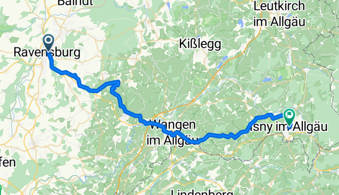
Ravensburg bis Isny
A cycling route starting in Ravensburg, Baden-Wurttemberg, Germany.
Overview
About this route
- 2 h 59 min
- Duration
- 48.9 km
- Distance
- 892 m
- Ascent
- 640 m
- Descent
- 16.4 km/h
- Avg. speed
- 721 m
- Max. altitude

Route quality
Waytypes & surfaces along the route
Waytypes
Quiet road
23 km
(47 %)
Road
9.8 km
(20 %)
Surfaces
Paved
45.5 km
(93 %)
Unpaved
1.5 km
(3 %)
Asphalt
45 km
(92 %)
Paved (undefined)
0.5 km
(1 %)
Continue with Bikemap
Use, edit, or download this cycling route
You would like to ride Ravensburg bis Isny or customize it for your own trip? Here is what you can do with this Bikemap route:
Free features
- Save this route as favorite or in collections
- Copy & plan your own version of this route
- Sync your route with Garmin or Wahoo
Premium features
Free trial for 3 days, or one-time payment. More about Bikemap Premium.
- Navigate this route on iOS & Android
- Export a GPX / KML file of this route
- Create your custom printout (try it for free)
- Download this route for offline navigation
Discover more Premium features.
Get Bikemap PremiumFrom our community
Other popular routes starting in Ravensburg
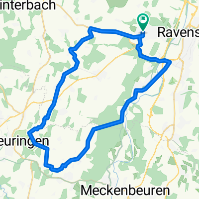
 Ravensburg - Waldburg - Runde
- Distance
- 31 km
- Ascent
- 514 m
- Descent
- 517 m
- Location
- Ravensburg, Baden-Wurttemberg, Germany
 RV_Kressbronn_Selmnau_Tettnang_RV
- Distance
- 54.7 km
- Ascent
- 366 m
- Descent
- 366 m
- Location
- Ravensburg, Baden-Wurttemberg, Germany
 RV_GehrenbergTurm_RV
- Distance
- 62.8 km
- Ascent
- 462 m
- Descent
- 464 m
- Location
- Ravensburg, Baden-Wurttemberg, Germany
 Ravensburg - Kressbronn - Runde
- Distance
- 67 km
- Ascent
- 2,730 m
- Descent
- 2,730 m
- Location
- Ravensburg, Baden-Wurttemberg, Germany
 RV_Kreuzweiher_Laimnau_RV
- Distance
- 45.4 km
- Ascent
- 286 m
- Descent
- 283 m
- Location
- Ravensburg, Baden-Wurttemberg, Germany
 Hochbergstraße nach Hochbergstraße 53/1
- Distance
- 29.1 km
- Ascent
- 178 m
- Descent
- 178 m
- Location
- Ravensburg, Baden-Wurttemberg, Germany
 Ravensburg - Hoechsten - Fleischwangen - Runde
- Distance
- 54.1 km
- Ascent
- 695 m
- Descent
- 694 m
- Location
- Ravensburg, Baden-Wurttemberg, Germany
 Ravensburg - Obereisenbach - Ettenkirchen - Runde
- Distance
- 40.6 km
- Ascent
- 470 m
- Descent
- 476 m
- Location
- Ravensburg, Baden-Wurttemberg, Germany
Open it in the app