
2025.8.28오후
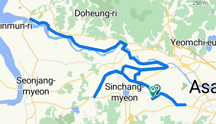
A cycling route starting in Asan, Chungcheongnam-do, South Korea.
Overview
About this route
- 6 h 53 min
- Duration
- 44.8 km
- Distance
- 199 m
- Ascent
- 194 m
- Descent
- 6.5 km/h
- Avg. speed
- 59 m
- Max. altitude
Route photos


Continue with Bikemap
Use, edit, or download this cycling route
You would like to ride 2025.8.28오후 or customize it for your own trip? Here is what you can do with this Bikemap route:
Free features
- Save this route as favorite or in collections
- Copy & plan your own version of this route
- Sync your route with Garmin or Wahoo
Premium features
Free trial for 3 days, or one-time payment. More about Bikemap Premium.
- Navigate this route on iOS & Android
- Export a GPX / KML file of this route
- Create your custom printout (try it for free)
- Download this route for offline navigation
Discover more Premium features.
Get Bikemap PremiumFrom our community
Other popular routes starting in Asan
 159, 평택호길, 평택시 to 52-55, 창내리, 평택시
- Distance
- 19.1 km
- Ascent
- 126 m
- Descent
- 129 m
- Location
- Asan, Chungcheongnam-do, South Korea
 탕정면 634-3 ~ 탕정면
- Distance
- 5 km
- Ascent
- 28 m
- Descent
- 48 m
- Location
- Asan, Chungcheongnam-do, South Korea
 2025.8.28오후
- Distance
- 44.8 km
- Ascent
- 199 m
- Descent
- 194 m
- Location
- Asan, Chungcheongnam-do, South Korea
 Moderate route in Asan-si
- Distance
- 9.2 km
- Ascent
- 139 m
- Descent
- 159 m
- Location
- Asan, Chungcheongnam-do, South Korea
 От 307-3 권곡동, 아산시 до 697 신부동, 천안시
- Distance
- 20.3 km
- Ascent
- 1,075 m
- Descent
- 1,040 m
- Location
- Asan, Chungcheongnam-do, South Korea
 work route main
- Distance
- 15.5 km
- Ascent
- 129 m
- Descent
- 177 m
- Location
- Asan, Chungcheongnam-do, South Korea
 2025.9.7 저녁
- Distance
- 30.4 km
- Ascent
- 184 m
- Descent
- 223 m
- Location
- Asan, Chungcheongnam-do, South Korea
 маршрут с Sinchang-myeon 17, Asan-si
- Distance
- 7.1 km
- Ascent
- 67 m
- Descent
- 86 m
- Location
- Asan, Chungcheongnam-do, South Korea
Open it in the app