
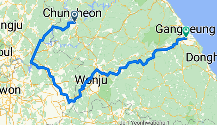
후평동 825-6 ~ 홍제동 111-7
A cycling route starting in Chuncheon, Gangwon-do, South Korea.
Overview
About this route
- 19 h 3 min
- Duration
- 316.3 km
- Distance
- 5,493 m
- Ascent
- 5,569 m
- Descent
- 16.6 km/h
- Avg. speed
- 948 m
- Max. altitude

Route photos


Route quality
Waytypes & surfaces along the route
Waytypes
Cycleway
126.5 km
(40 %)
Road
88.6 km
(28 %)
Surfaces
Paved
246.7 km
(78 %)
Unpaved
9.5 km
(3 %)
Asphalt
211.9 km
(67 %)
Concrete
19 km
(6 %)
Continue with Bikemap
Use, edit, or download this cycling route
You would like to ride 후평동 825-6 ~ 홍제동 111-7 or customize it for your own trip? Here is what you can do with this Bikemap route:
Free features
- Save this route as favorite or in collections
- Copy & plan your own version of this route
- Split it into stages to create a multi-day tour
- Sync your route with Garmin or Wahoo
Premium features
Free trial for 3 days, or one-time payment. More about Bikemap Premium.
- Navigate this route on iOS & Android
- Export a GPX / KML file of this route
- Create your custom printout (try it for free)
- Download this route for offline navigation
Discover more Premium features.
Get Bikemap PremiumFrom our community
Other popular routes starting in Chuncheon
 1234
1234- Distance
- 168.6 km
- Ascent
- 1,968 m
- Descent
- 2,033 m
- Location
- Chuncheon, Gangwon-do, South Korea
 Chuncheon Circular RTC
- Distance
- 27.5 km
- Ascent
- 215 m
- Descent
- 221 m
- Location
- Chuncheon, Gangwon-do, South Korea
 춘천-배후령-하나로 간동면-파로호-화천읍-부다리-하나로 고탄리-세미고개-춘천
- Distance
- 84.4 km
- Ascent
- 1,874 m
- Descent
- 1,870 m
- Location
- Chuncheon, Gangwon-do, South Korea
 근화동, 춘천시에서 근화동, 춘천시까지
- Distance
- 30.2 km
- Ascent
- 151 m
- Descent
- 146 m
- Location
- Chuncheon, Gangwon-do, South Korea
![송암동 162, 춘천시Ph0]으로 라우팅](https://media.bikemap.net/routes/13543145/staticmaps/in_b8635e0d-c5ad-4443-b5ee-4a257712591e_400x400_bikemap-2021-3D-static.png) 송암동 162, 춘천시Ph0]으로 라우팅
송암동 162, 춘천시Ph0]으로 라우팅- Distance
- 6.4 km
- Ascent
- 67 m
- Descent
- 39 m
- Location
- Chuncheon, Gangwon-do, South Korea
 중도상하중도
- Distance
- 27.8 km
- Ascent
- 68 m
- Descent
- 76 m
- Location
- Chuncheon, Gangwon-do, South Korea
 의암호 코스
- Distance
- 29.3 km
- Ascent
- 432 m
- Descent
- 432 m
- Location
- Chuncheon, Gangwon-do, South Korea
 춘천역 - 당산역
- Distance
- 127.7 km
- Ascent
- 1,449 m
- Descent
- 1,504 m
- Location
- Chuncheon, Gangwon-do, South Korea
Open it in the app