

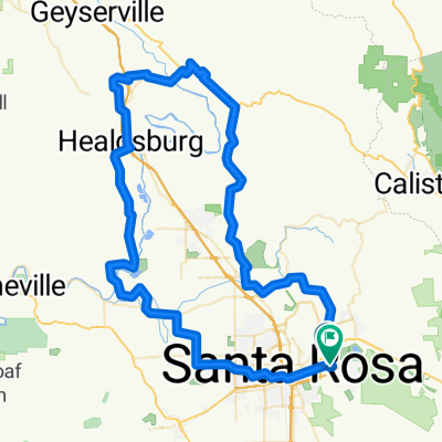
kpg 61 bday ride
A cycling route starting in Santa Rosa, California, United States.
Overview
About this route
- 6 h 7 min
- Duration
- 96.4 km
- Distance
- 902 m
- Ascent
- 899 m
- Descent
- 15.8 km/h
- Avg. speed
- 172 m
- Max. altitude
Route quality
Waytypes & surfaces along the route
Waytypes
Road
30.9 km
(32 %)
Quiet road
24.1 km
(25 %)
Surfaces
Paved
25.1 km
(26 %)
Asphalt
21.2 km
(22 %)
Paved (undefined)
3.9 km
(4 %)
Undefined
71.3 km
(74 %)
Continue with Bikemap
Use, edit, or download this cycling route
You would like to ride kpg 61 bday ride or customize it for your own trip? Here is what you can do with this Bikemap route:
Free features
- Save this route as favorite or in collections
- Copy & plan your own version of this route
- Split it into stages to create a multi-day tour
- Sync your route with Garmin or Wahoo
Premium features
Free trial for 3 days, or one-time payment. More about Bikemap Premium.
- Navigate this route on iOS & Android
- Export a GPX / KML file of this route
- Create your custom printout (try it for free)
- Download this route for offline navigation
Discover more Premium features.
Get Bikemap PremiumFrom our community
Other popular routes starting in Santa Rosa
 kpg 61 bday ride
- Distance
- 98 km
- Ascent
- 905 m
- Descent
- 902 m
- Location
- Santa Rosa, California, United States
 early morning loop
- Distance
- 63.1 km
- Ascent
- 587 m
- Descent
- 596 m
- Location
- Santa Rosa, California, United States
 Super Fountaingrove
- Distance
- 20.7 km
- Ascent
- 518 m
- Descent
- 518 m
- Location
- Santa Rosa, California, United States
 kpg 61 bday ride
- Distance
- 96.4 km
- Ascent
- 902 m
- Descent
- 899 m
- Location
- Santa Rosa, California, United States
 Santa Rosa Loop
- Distance
- 52.2 km
- Ascent
- 533 m
- Descent
- 536 m
- Location
- Santa Rosa, California, United States
 Restful route
- Distance
- 6 km
- Ascent
- 74 m
- Descent
- 72 m
- Location
- Santa Rosa, California, United States
 kpg 60 bday ride
- Distance
- 98 km
- Ascent
- 905 m
- Descent
- 902 m
- Location
- Santa Rosa, California, United States
 Bennett Valley-Lawndale-Oakmont-Santa Rosa
- Distance
- 44.3 km
- Ascent
- 468 m
- Descent
- 468 m
- Location
- Santa Rosa, California, United States
Open it in the app