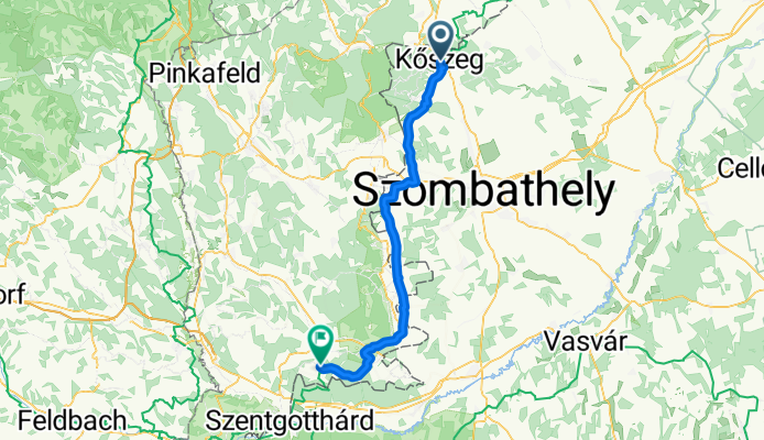
Overview
About this route
- 3 h 53 min
- Duration
- 60.3 km
- Distance
- 502 m
- Ascent
- 458 m
- Descent
- 15.6 km/h
- Avg. speed
- 349 m
- Max. altitude
Part of
EV13-West
20 stages
Continue with Bikemap
Use, edit, or download this cycling route
You would like to ride Kőszeg - Inzenhof or customize it for your own trip? Here is what you can do with this Bikemap route:
Free features
- Save this route as favorite or in collections
- Copy & plan your own version of this route
- Sync your route with Garmin or Wahoo
Premium features
Free trial for 3 days, or one-time payment. More about Bikemap Premium.
- Navigate this route on iOS & Android
- Export a GPX / KML file of this route
- Create your custom printout (try it for free)
- Download this route for offline navigation
Discover more Premium features.
Get Bikemap PremiumFrom our community
Other popular routes starting in Kőszeg
Kőszeg3- Distance
- 10.6 km
- Ascent
- 77 m
- Descent
- 29 m
- Location
- Kőszeg, Vas County, Hungary
Kőszeg - Inzenhof- Distance
- 60.3 km
- Ascent
- 502 m
- Descent
- 458 m
- Location
- Kőszeg, Vas County, Hungary
E13 Sopron (slow) /2- Distance
- 55.9 km
- Ascent
- 532 m
- Descent
- 606 m
- Location
- Kőszeg, Vas County, Hungary
VELOREGIO_21- Distance
- 112.9 km
- Ascent
- 276 m
- Descent
- 276 m
- Location
- Kőszeg, Vas County, Hungary
VELOREGIO_14.- Distance
- 33.7 km
- Ascent
- 636 m
- Descent
- 635 m
- Location
- Kőszeg, Vas County, Hungary
Route in Kőszeg- Distance
- 52.4 km
- Ascent
- 1,115 m
- Descent
- 1,115 m
- Location
- Kőszeg, Vas County, Hungary
Kőszeg-Ausztria- Distance
- 67.8 km
- Ascent
- 986 m
- Descent
- 987 m
- Location
- Kőszeg, Vas County, Hungary
Kőszeg-Bük-Acsád-Kőszegfalva-Kőszeg- Distance
- 48.8 km
- Ascent
- 216 m
- Descent
- 213 m
- Location
- Kőszeg, Vas County, Hungary
Open it in the app


