
Overview
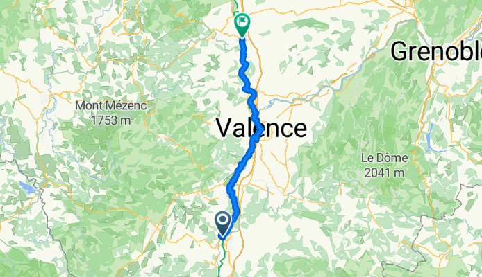
About this route
- 6 h 11 min
- Duration
- 103.1 km
- Distance
- 442 m
- Ascent
- 383 m
- Descent
- 16.7 km/h
- Avg. speed
- 156 m
- Max. altitude
Part of
test1
15 stages
Route quality
Waytypes & surfaces along the route
Waytypes
Cycleway
70.1 km
(68 %)
Quiet road
19.6 km
(19 %)
Surfaces
Paved
58.8 km
(57 %)
Unpaved
8.2 km
(8 %)
Asphalt
58.8 km
(57 %)
Loose gravel
5.2 km
(5 %)
Continue with Bikemap
Use, edit, or download this cycling route
You would like to ride Ancône - Andancette or customize it for your own trip? Here is what you can do with this Bikemap route:
Free features
- Save this route as favorite or in collections
- Copy & plan your own version of this route
- Split it into stages to create a multi-day tour
- Sync your route with Garmin or Wahoo
Premium features
Free trial for 3 days, or one-time payment. More about Bikemap Premium.
- Navigate this route on iOS & Android
- Export a GPX / KML file of this route
- Create your custom printout (try it for free)
- Download this route for offline navigation
Discover more Premium features.
Get Bikemap PremiumFrom our community
Other popular routes starting in Ancône
 Ancône - Andancette
- Distance
- 103.1 km
- Ascent
- 442 m
- Descent
- 383 m
- Location
- Ancône, Auvergne-Rhône-Alpes, France
 Ancone de lile blanc do Awinion de punt
- Distance
- 159.6 km
- Ascent
- 33 m
- Descent
- 88 m
- Location
- Ancône, Auvergne-Rhône-Alpes, France
 Ancône-Champagne
- Distance
- 95.2 km
- Ascent
- 280 m
- Descent
- 227 m
- Location
- Ancône, Auvergne-Rhône-Alpes, France
 Curas
Curas- Distance
- 84.9 km
- Ascent
- 963 m
- Descent
- 963 m
- Location
- Ancône, Auvergne-Rhône-Alpes, France
 De D11, Ancone à Rue Général Rampon 145, Saint-Fortunat-sur-Eyrieux
- Distance
- 49.8 km
- Ascent
- 759 m
- Descent
- 680 m
- Location
- Ancône, Auvergne-Rhône-Alpes, France
 Szprycha wzdłuż Rodanu do Lazurowego Wybrzeża - 11.07.2016 r.
- Distance
- 105.8 km
- Ascent
- 44 m
- Descent
- 101 m
- Location
- Ancône, Auvergne-Rhône-Alpes, France
 Montélimar - Aix-en-Provence
- Distance
- 164.3 km
- Ascent
- 686 m
- Descent
- 569 m
- Location
- Ancône, Auvergne-Rhône-Alpes, France
 1064–1118 Chemin de l'Île Blanc, Rochemaure à 27 Route du Plan d'Eau, Charmes-sur-Rhône
- Distance
- 38.2 km
- Ascent
- 189 m
- Descent
- 155 m
- Location
- Ancône, Auvergne-Rhône-Alpes, France
Open it in the app