
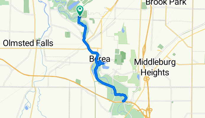
3) MetroPark Willow Bend Picnic Area, Valley Parkway, Brook Park to Walter F Ehrnfelt Covered Bridge historic landmark at Whitney Rd, Strongsville
A cycling route starting in Berea, Ohio, United States.
Overview
About this route
Willow Bend Picnic Area, Valley Parkway, Brook Park to Walter F Ehrnfelt Covered Bridge historic landmark at Whitney Rd, Strongsville.
- 58 min
- Duration
- 16.8 km
- Distance
- 86 m
- Ascent
- 89 m
- Descent
- 17.4 km/h
- Avg. speed
- 251 m
- Max. altitude

Route quality
Waytypes & surfaces along the route
Waytypes
Cycleway
16.1 km
(96 %)
Road
0.3 km
(2 %)
Surfaces
Paved
15.3 km
(91 %)
Asphalt
15.2 km
(90 %)
Wood
0.1 km
(<1 %)
Undefined
1.6 km
(9 %)
Continue with Bikemap
Use, edit, or download this cycling route
You would like to ride 3) MetroPark Willow Bend Picnic Area, Valley Parkway, Brook Park to Walter F Ehrnfelt Covered Bridge historic landmark at Whitney Rd, Strongsville or customize it for your own trip? Here is what you can do with this Bikemap route:
Free features
- Save this route as favorite or in collections
- Copy & plan your own version of this route
- Sync your route with Garmin or Wahoo
Premium features
Free trial for 3 days, or one-time payment. More about Bikemap Premium.
- Navigate this route on iOS & Android
- Export a GPX / KML file of this route
- Create your custom printout (try it for free)
- Download this route for offline navigation
Discover more Premium features.
Get Bikemap PremiumFrom our community
Other popular routes starting in Berea
 3rd Ride
- Distance
- 3.3 km
- Ascent
- 4 m
- Descent
- 3 m
- Location
- Berea, Ohio, United States
 From Berea to Cleveland
- Distance
- 21 km
- Ascent
- 164 m
- Descent
- 175 m
- Location
- Berea, Ohio, United States
 Emerald Necklace Trail, Berea to 327 Prospect St, Berea
- Distance
- 11.9 km
- Ascent
- 31 m
- Descent
- 55 m
- Location
- Berea, Ohio, United States
 Route to South Mastick Picnic Area
- Distance
- 9 km
- Ascent
- 61 m
- Descent
- 83 m
- Location
- Berea, Ohio, United States
 Recovered Route
- Distance
- 10.9 km
- Ascent
- 54 m
- Descent
- 57 m
- Location
- Berea, Ohio, United States
 September 29, 2018
- Distance
- 20.1 km
- Ascent
- 273 m
- Descent
- 274 m
- Location
- Berea, Ohio, United States
 Tour of Cuyahoga Valley & Hinkley
- Distance
- 87.7 km
- Ascent
- 504 m
- Descent
- 508 m
- Location
- Berea, Ohio, United States
 Emerald Necklace Trail, Berea to Cleveland Metro Park Dr, Berea
- Distance
- 23.2 km
- Ascent
- 90 m
- Descent
- 90 m
- Location
- Berea, Ohio, United States
Open it in the app