
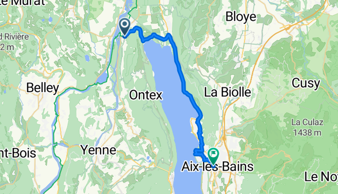
Chanaz - Aix-les-Bains - 1-Chanaz - Aix-les-Bains
A cycling route starting in Châtillon, Auvergne-Rhône-Alpes, France.
Overview
About this route
Vous quittez Chanaz et ses nombreuses échoppes d’artisan pour reprendre la ViaRhôna jusque Portout où le lac du Bourget pointe le bout de son nez.Vous pouvez choisir de pédaler avec en ligne de mire le lac du Bourget et Aix-les-Bains ou vous avez la possibilité de rejoindre la station thermale en embarquant sur un bateau avec vos vélos (en juillet et août uniquement). - 1-Chanaz - Aix-les-Bains
- 1 h 41 min
- Duration
- 24.5 km
- Distance
- 390 m
- Ascent
- 383 m
- Descent
- 14.5 km/h
- Avg. speed
- 302 m
- Max. altitude
Continue with Bikemap
Use, edit, or download this cycling route
You would like to ride Chanaz - Aix-les-Bains - 1-Chanaz - Aix-les-Bains or customize it for your own trip? Here is what you can do with this Bikemap route:
Free features
- Save this route as favorite or in collections
- Copy & plan your own version of this route
- Sync your route with Garmin or Wahoo
Premium features
Free trial for 3 days, or one-time payment. More about Bikemap Premium.
- Navigate this route on iOS & Android
- Export a GPX / KML file of this route
- Create your custom printout (try it for free)
- Download this route for offline navigation
Discover more Premium features.
Get Bikemap PremiumFrom our community
Other popular routes starting in Châtillon
 Viarhona et V63
- Distance
- 475.2 km
- Ascent
- 471 m
- Descent
- 473 m
- Location
- Châtillon, Auvergne-Rhône-Alpes, France
 Alpen 2015 - Dag 5
- Distance
- 95.9 km
- Ascent
- 2,079 m
- Descent
- 1,865 m
- Location
- Châtillon, Auvergne-Rhône-Alpes, France
 De Conjux à Vions - Chanaz
- Distance
- 13 km
- Ascent
- 51 m
- Descent
- 45 m
- Location
- Châtillon, Auvergne-Rhône-Alpes, France
 2014.07.06 Via Rhona
- Distance
- 69.2 km
- Ascent
- 170 m
- Descent
- 131 m
- Location
- Châtillon, Auvergne-Rhône-Alpes, France
 67km2100hmSaintPierreDeCurtille
- Distance
- 67.3 km
- Ascent
- 0 m
- Descent
- 0 m
- Location
- Châtillon, Auvergne-Rhône-Alpes, France
 Etape 3 (58km) - Camping de Chanaz à celui de Morestel
- Distance
- 58.4 km
- Ascent
- 263 m
- Descent
- 284 m
- Location
- Châtillon, Auvergne-Rhône-Alpes, France
 chanazJongieuChanaz
- Distance
- 37.5 km
- Ascent
- 1,135 m
- Descent
- 1,143 m
- Location
- Châtillon, Auvergne-Rhône-Alpes, France
 Chanaz Ontex
- Distance
- 35.5 km
- Ascent
- 1,192 m
- Descent
- 1,176 m
- Location
- Châtillon, Auvergne-Rhône-Alpes, France
Open it in the app