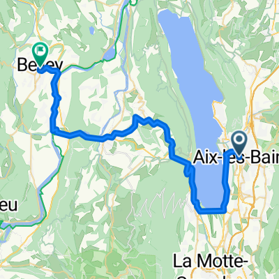
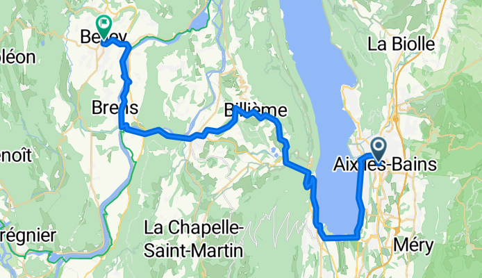
Aix-les-Bains - Belley - 2-Aix-les-Bains - Belley
A cycling route starting in Aix-les-Bains, Auvergne-Rh么ne-Alpes, France.
Overview
About this route
Follow the bike path along Lake Bourget where you will surely not resist the urge to take a dip. After Le Bourget-du-Lac, you will need to climb some Savoyard hills to reach the Chat Tunnel, specially designed for cyclists. You won鈥檛 regret your effort as you enjoy the view! Then wander through the small country roads and let yourself be tempted by a tasting of Savoyard wines around Yenne and the Balme Gorges. Next, you reach Belley, the birthplace of gastronome Brillat-Savarin and capital of Bugey. - 2-Aix-les-Bains - Belley
- 2 h 51 min
- Duration
- 41.8 km
- Distance
- 579 m
- Ascent
- 545 m
- Descent
- 14.7 km/h
- Avg. speed
- 419 m
- Max. altitude
Continue with Bikemap
Use, edit, or download this cycling route
You would like to ride Aix-les-Bains - Belley - 2-Aix-les-Bains - Belley or customize it for your own trip? Here is what you can do with this Bikemap route:
Free features
- Save this route as favorite or in collections
- Copy & plan your own version of this route
- Sync your route with Garmin or Wahoo
Premium features
Free trial for 3 days, or one-time payment. More about Bikemap Premium.
- Navigate this route on iOS & Android
- Export a GPX / KML file of this route
- Create your custom printout (try it for free)
- Download this route for offline navigation
Discover more Premium features.
Get Bikemap PremiumFrom our community
Other popular routes starting in Aix-les-Bains
 Aix-les-Bains - Belley - 2-Aix-les-Bains - Belley Aix-les-Bains - Belley - 2-Aix-les-Bains - Belley- Distance
- 41.8 km
- Ascent
- 579 m
- Descent
- 545 m
- Location
- Aix-les-Bains, Auvergne-Rh么ne-Alpes, France
 
 De Rue du Maroc 85, Aix-les-Bains 脿 Chemin la Tessonni猫re d'en Bas 117, La Motte-Servolex De Rue du Maroc 85, Aix-les-Bains 脿 Chemin la Tessonni猫re d'en Bas 117, La Motte-Servolex- Distance
- 14.3 km
- Ascent
- 154 m
- Descent
- 120 m
- Location
- Aix-les-Bains, Auvergne-Rh么ne-Alpes, France
 
 Mont Revard & more Mont Revard & more- Distance
- 113.1 km
- Ascent
- 2,272 m
- Descent
- 2,392 m
- Location
- Aix-les-Bains, Auvergne-Rh么ne-Alpes, France
 
 ballades des 3 lacs avec D+ ballades des 3 lacs avec D+- Distance
- 230.9 km
- Ascent
- 3,430 m
- Descent
- 3,193 m
- Location
- Aix-les-Bains, Auvergne-Rh么ne-Alpes, France
 
 Pyenees to the Alps day 6 a Pyenees to the Alps day 6 a- Distance
- 85.6 km
- Ascent
- 690 m
- Descent
- 564 m
- Location
- Aix-les-Bains, Auvergne-Rh么ne-Alpes, France
 
 Aix-Les-Bains - Annecy Semnoz Aix-Les-Bains - Annecy Semnoz- Distance
- 121.5 km
- Ascent
- 3,356 m
- Descent
- 2,052 m
- Location
- Aix-les-Bains, Auvergne-Rh么ne-Alpes, France
 
 3 - Aux-Les-Bains to Talloires - Backup 1 3 - Aux-Les-Bains to Talloires - Backup 1- Distance
- 107.2 km
- Ascent
- 867 m
- Descent
- 678 m
- Location
- Aix-les-Bains, Auvergne-Rh么ne-Alpes, France
 
 Untitled route Untitled route- Distance
- 75.1 km
- Ascent
- 369 m
- Descent
- 294 m
- Location
- Aix-les-Bains, Auvergne-Rh么ne-Alpes, France
 
Open it in the app


