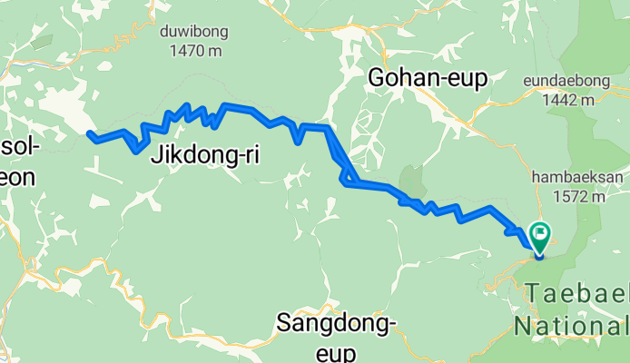
정선군에서 정선군까지
A cycling route starting in T’aebaek, Gangwon-do, South Korea.
Overview
About this route
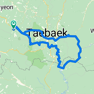
Round trip Manhangjae-Saebijae
- 5 h 28 min
- Duration
- 64 km
- Distance
- 1,985 m
- Ascent
- 1,989 m
- Descent
- 11.7 km/h
- Avg. speed
- 1,328 m
- Max. altitude
Route photos
Route quality
Waytypes & surfaces along the route
Waytypes
Track
55.1 km
(86 %)
Path
4.5 km
(7 %)
Surfaces
Paved
3.2 km
(5 %)
Unpaved
58.3 km
(91 %)
Gravel
30.7 km
(48 %)
Unpaved (undefined)
25 km
(39 %)
Continue with Bikemap
Use, edit, or download this cycling route
You would like to ride 정선군에서 정선군까지 or customize it for your own trip? Here is what you can do with this Bikemap route:
Free features
- Save this route as favorite or in collections
- Copy & plan your own version of this route
- Sync your route with Garmin or Wahoo
Premium features
Free trial for 3 days, or one-time payment. More about Bikemap Premium.
- Navigate this route on iOS & Android
- Export a GPX / KML file of this route
- Create your custom printout (try it for free)
- Download this route for offline navigation
Discover more Premium features.
Get Bikemap PremiumFrom our community
Other popular routes starting in T’aebaek
고한읍Ph0]으로 라우팅- Distance
- 6.2 km
- Ascent
- 25 m
- Descent
- 451 m
- Location
- T’aebaek, Gangwon-do, South Korea
강원랜드-두문동재-석개재-만항재-강원랜드- Distance
- 118.3 km
- Ascent
- 2,676 m
- Descent
- 2,639 m
- Location
- T’aebaek, Gangwon-do, South Korea
중동면-만항재- Distance
- 59.9 km
- Ascent
- 824 m
- Descent
- 1,422 m
- Location
- T’aebaek, Gangwon-do, South Korea
점심 라이딩- Distance
- 58.1 km
- Ascent
- 1,529 m
- Descent
- 1,526 m
- Location
- T’aebaek, Gangwon-do, South Korea
PT64_Taebaek- Distance
- 214.9 km
- Ascent
- 11,446 m
- Descent
- 11,567 m
- Location
- T’aebaek, Gangwon-do, South Korea
정선군에서 정선군까지- Distance
- 64 km
- Ascent
- 1,985 m
- Descent
- 1,989 m
- Location
- T’aebaek, Gangwon-do, South Korea
서학로, 태백시 to 사북읍 산153-18, 정선군- Distance
- 81.1 km
- Ascent
- 966 m
- Descent
- 1,366 m
- Location
- T’aebaek, Gangwon-do, South Korea
삼수동 강원도, 태백시 to 서학로, 태백시- Distance
- 45.9 km
- Ascent
- 1,543 m
- Descent
- 1,205 m
- Location
- T’aebaek, Gangwon-do, South Korea
Open it in the app

