
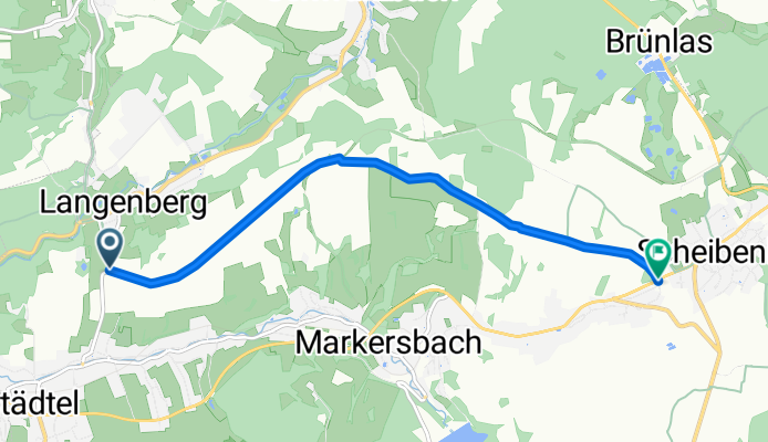
Emmlerweg
A cycling route starting in Raschau, Saxony, Germany.
Overview
About this route
ehemalige Bahnstrecke von Langenberg nach Scheibenberg
- -:--
- Duration
- 5.8 km
- Distance
- 185 m
- Ascent
- 38 m
- Descent
- ---
- Avg. speed
- ---
- Max. altitude

Route quality
Waytypes & surfaces along the route
Waytypes
Track
5.8 km
(100 %)
Surfaces
Paved
4.8 km
(83 %)
Unpaved
1 km
(17 %)
Asphalt
4.8 km
(83 %)
Gravel
0.8 km
(13 %)
Ground
0.2 km
(4 %)
Continue with Bikemap
Use, edit, or download this cycling route
You would like to ride Emmlerweg or customize it for your own trip? Here is what you can do with this Bikemap route:
Free features
- Save this route as favorite or in collections
- Copy & plan your own version of this route
- Sync your route with Garmin or Wahoo
Premium features
Free trial for 3 days, or one-time payment. More about Bikemap Premium.
- Navigate this route on iOS & Android
- Export a GPX / KML file of this route
- Create your custom printout (try it for free)
- Download this route for offline navigation
Discover more Premium features.
Get Bikemap PremiumFrom our community
Other popular routes starting in Raschau
 Raschau-Geyerischer TEICH
- Distance
- 27.5 km
- Ascent
- 433 m
- Descent
- 282 m
- Location
- Raschau, Saxony, Germany
 Raschau-Fichtelberg
- Distance
- 19.5 km
- Ascent
- 763 m
- Descent
- 33 m
- Location
- Raschau, Saxony, Germany
 Emmlerweg
- Distance
- 5.8 km
- Ascent
- 185 m
- Descent
- 38 m
- Location
- Raschau, Saxony, Germany
 Beethovenstraße 24, Raschau-Markersbach nach Beethovenstraße 22A, Raschau-Markersbach
- Distance
- 17.3 km
- Ascent
- 371 m
- Descent
- 453 m
- Location
- Raschau, Saxony, Germany
 Beethovenstraße 24, Raschau-Markersbach nach Beethovenstraße 24, Raschau-Markersbach
- Distance
- 33.6 km
- Ascent
- 325 m
- Descent
- 565 m
- Location
- Raschau, Saxony, Germany
 500. Tellerhäuser und Scheibenberg
- Distance
- 78.1 km
- Ascent
- 1,216 m
- Descent
- 1,216 m
- Location
- Raschau, Saxony, Germany
 Königsetappe 3_ Raschau_Markersbach_Crottendorf_Neudorf_Hammerunterwiesenthal_Bärenstein_Vejprty_Stausee_Kotlina_Medenec_Horni Halze_Perstejn_Srni_Meluzina (109
- Distance
- 76.5 km
- Ascent
- 1,669 m
- Descent
- 888 m
- Location
- Raschau, Saxony, Germany
 Rundfahrt Zwönitz
- Distance
- 56.5 km
- Ascent
- 821 m
- Descent
- 826 m
- Location
- Raschau, Saxony, Germany
Open it in the app