Tuderschitz - Krumpendorf - Tigring
A cycling route starting in Moosburg, Carinthia, Austria.
Overview
About this route
Start at Panoramastr. in Tuderschitz towards Hohenfeld Castle Drasing in the direction of Krumpendorf (forest path), then before the Halleggerteichen towards Tultschnig to Wölfnitz, and at Ponfeld go right towards Faning Tigring and return to Tuderschitz Panoramastr. via Moosburg. ROUTE DISTANCE 28.6 Km
- -:--
- Duration
- 28.6 km
- Distance
- 423 m
- Ascent
- 414 m
- Descent
- ---
- Avg. speed
- ---
- Max. altitude
Route quality
Waytypes & surfaces along the route
Waytypes
Quiet road
16.3 km
(57 %)
Road
3.7 km
(13 %)
Surfaces
Paved
10.6 km
(37 %)
Unpaved
2.9 km
(10 %)
Asphalt
10.6 km
(37 %)
Gravel
2.3 km
(8 %)
Continue with Bikemap
Use, edit, or download this cycling route
You would like to ride Tuderschitz - Krumpendorf - Tigring or customize it for your own trip? Here is what you can do with this Bikemap route:
Free features
- Save this route as favorite or in collections
- Copy & plan your own version of this route
- Sync your route with Garmin or Wahoo
Premium features
Free trial for 3 days, or one-time payment. More about Bikemap Premium.
- Navigate this route on iOS & Android
- Export a GPX / KML file of this route
- Create your custom printout (try it for free)
- Download this route for offline navigation
Discover more Premium features.
Get Bikemap PremiumFrom our community
Other popular routes starting in Moosburg
- Bärndorfer Runde
- Distance
- 13.6 km
- Ascent
- 386 m
- Descent
- 385 m
- Location
- Moosburg, Carinthia, Austria
- Moosburg die zweite
- Distance
- 29.5 km
- Ascent
- 296 m
- Descent
- 296 m
- Location
- Moosburg, Carinthia, Austria
- Tuderschitz - Krumpendorf - Tigring
- Distance
- 28.6 km
- Ascent
- 423 m
- Descent
- 414 m
- Location
- Moosburg, Carinthia, Austria
- Wörtherseerundfahrt über Keutschacherstr.
- Distance
- 59.1 km
- Ascent
- 546 m
- Descent
- 537 m
- Location
- Moosburg, Carinthia, Austria
- Hochrindlrundfahrt
- Distance
- 94.6 km
- Ascent
- 1,490 m
- Descent
- 1,495 m
- Location
- Moosburg, Carinthia, Austria
- MTB-Trail: Moosburg-Prosintschach-SallachAussicht-Bannwald-Moosburg
- Distance
- 12.1 km
- Ascent
- 430 m
- Descent
- 428 m
- Location
- Moosburg, Carinthia, Austria
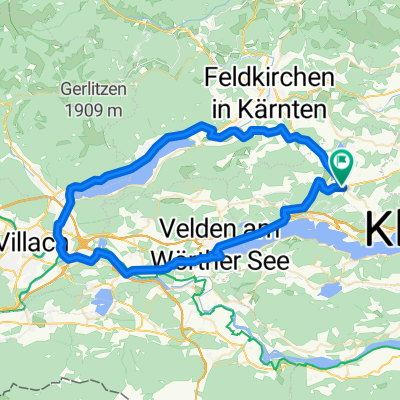
- Moosburg_Ossiacher See_Velden
- Distance
- 64.2 km
- Ascent
- 298 m
- Descent
- 292 m
- Location
- Moosburg, Carinthia, Austria
- MTB-Trail: Pörtschach/Zocklwirt-Bannwald-TRAILs
- Distance
- 8.3 km
- Ascent
- 327 m
- Descent
- 327 m
- Location
- Moosburg, Carinthia, Austria
Open it in the app