
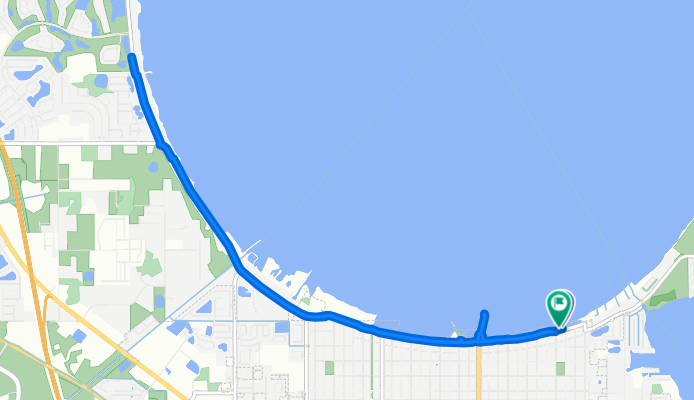
Lakeshore Blvd, Saint Cloud to Lakeshore Blvd, Saint Cloud
A cycling route starting in St. Cloud, Florida, United States.
Overview
About this route
- 56 min
- Duration
- 14.4 km
- Distance
- 8 m
- Ascent
- 9 m
- Descent
- 15.4 km/h
- Avg. speed
- 23 m
- Max. altitude

Route quality
Waytypes & surfaces along the route
Waytypes
Cycleway
11.2 km
(78 %)
Road
2.2 km
(15 %)
Surfaces
Paved
11.2 km
(78 %)
Paved (undefined)
11.1 km
(77 %)
Asphalt
0.1 km
(1 %)
Undefined
3.2 km
(22 %)
Continue with Bikemap
Use, edit, or download this cycling route
You would like to ride Lakeshore Blvd, Saint Cloud to Lakeshore Blvd, Saint Cloud or customize it for your own trip? Here is what you can do with this Bikemap route:
Free features
- Save this route as favorite or in collections
- Copy & plan your own version of this route
- Sync your route with Garmin or Wahoo
Premium features
Free trial for 3 days, or one-time payment. More about Bikemap Premium.
- Navigate this route on iOS & Android
- Export a GPX / KML file of this route
- Create your custom printout (try it for free)
- Download this route for offline navigation
Discover more Premium features.
Get Bikemap PremiumFrom our community
Other popular routes starting in St. Cloud
 Macy Island Road to Macy Island Road
- Distance
- 14.1 km
- Ascent
- 42 m
- Descent
- 7 m
- Location
- St. Cloud, Florida, United States
 Goldeneye Lane to Goldeneye Lane
- Distance
- 14.7 km
- Ascent
- 48 m
- Descent
- 23 m
- Location
- St. Cloud, Florida, United States
 Goldeneye Lane to Goldeneye Lane
- Distance
- 7.7 km
- Ascent
- 31 m
- Descent
- 11 m
- Location
- St. Cloud, Florida, United States
 Narcoosee Road Race
- Distance
- 13.4 km
- Ascent
- 49 m
- Descent
- 47 m
- Location
- St. Cloud, Florida, United States
 Old Canoe Creek Road to Goldeneye Lane
- Distance
- 39.2 km
- Ascent
- 54 m
- Descent
- 27 m
- Location
- St. Cloud, Florida, United States
 Old Canoe Creek Road to Goldeneye Lane
- Distance
- 39.1 km
- Ascent
- 61 m
- Descent
- 23 m
- Location
- St. Cloud, Florida, United States
 Goldeneye Lane to Canoe Creek Road
- Distance
- 16.5 km
- Ascent
- 42 m
- Descent
- 16 m
- Location
- St. Cloud, Florida, United States
 Pintail Lane to Goldeneye Lane
- Distance
- 16.1 km
- Ascent
- 32 m
- Descent
- 3 m
- Location
- St. Cloud, Florida, United States
Open it in the app