

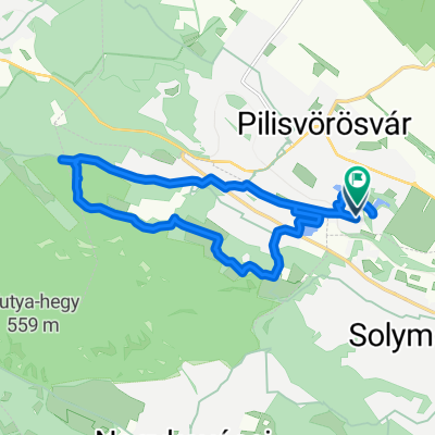
Kofola Kör
A cycling route starting in Pilisvörösvár, Pest County, Hungary.
Overview
About this route
Fully asphalted. Passable even with "virsli" (hot dog-shaped) tires. The route starts at main road 10 and runs on a bike path on the Pest side. One section touches Slovakia. (Esztergom - Szalka)
- -:--
- Duration
- 129.4 km
- Distance
- 364 m
- Ascent
- 364 m
- Descent
- ---
- Avg. speed
- ---
- Max. altitude

Route quality
Waytypes & surfaces along the route
Waytypes
Cycleway
32.3 km
(25 %)
Quiet road
25.9 km
(20 %)
Surfaces
Paved
85.4 km
(66 %)
Unpaved
5.2 km
(4 %)
Asphalt
73.7 km
(57 %)
Concrete
6.5 km
(5 %)
Route highlights
Points of interest along the route
Accommodation after 29.9 km
Kajálda: Kofola és Tátrai Tea
Accommodation after 33.6 km
Kocsma
Continue with Bikemap
Use, edit, or download this cycling route
You would like to ride Kofola Kör or customize it for your own trip? Here is what you can do with this Bikemap route:
Free features
- Save this route as favorite or in collections
- Copy & plan your own version of this route
- Split it into stages to create a multi-day tour
- Sync your route with Garmin or Wahoo
Premium features
Free trial for 3 days, or one-time payment. More about Bikemap Premium.
- Navigate this route on iOS & Android
- Export a GPX / KML file of this route
- Create your custom printout (try it for free)
- Download this route for offline navigation
Discover more Premium features.
Get Bikemap PremiumFrom our community
Other popular routes starting in Pilisvörösvár
 Kofola Kör
- Distance
- 129.4 km
- Ascent
- 364 m
- Descent
- 364 m
- Location
- Pilisvörösvár, Pest County, Hungary
 Harcsa utca - Harcsa utca
- Distance
- 14.9 km
- Ascent
- 199 m
- Descent
- 244 m
- Location
- Pilisvörösvár, Pest County, Hungary
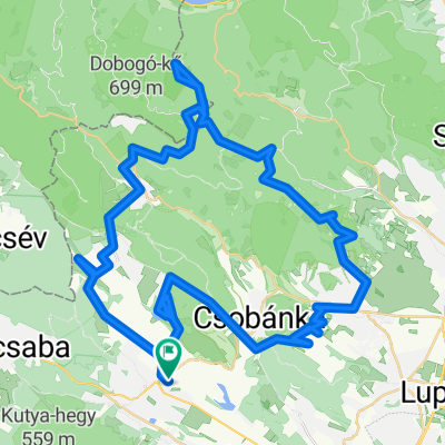
 P.vörösvár-Dobogókő-P.vörösvár
- Distance
- 64.8 km
- Ascent
- 1,141 m
- Descent
- 1,141 m
- Location
- Pilisvörösvár, Pest County, Hungary
 Pilisvörösvár-Teca kocsma( Pilisszentlélek)-Pilisvörösvár
- Distance
- 42.2 km
- Ascent
- 907 m
- Descent
- 905 m
- Location
- Pilisvörösvár, Pest County, Hungary
 Prédikálószék, Lajos-forrás és Kő hegy 60k
- Distance
- 69.9 km
- Ascent
- 1,750 m
- Descent
- 1,754 m
- Location
- Pilisvörösvár, Pest County, Hungary
 Pvörösvár-Dobogókő
- Distance
- 19.7 km
- Ascent
- 642 m
- Descent
- 132 m
- Location
- Pilisvörösvár, Pest County, Hungary
 Szerdai Dobogókő terv
- Distance
- 88.2 km
- Ascent
- 1,891 m
- Descent
- 1,891 m
- Location
- Pilisvörösvár, Pest County, Hungary
 Csuka utca 11, Pilisvörösvár - Szabadság utca 20, Solymár
- Distance
- 5.5 km
- Ascent
- 105 m
- Descent
- 95 m
- Location
- Pilisvörösvár, Pest County, Hungary
Open it in the app