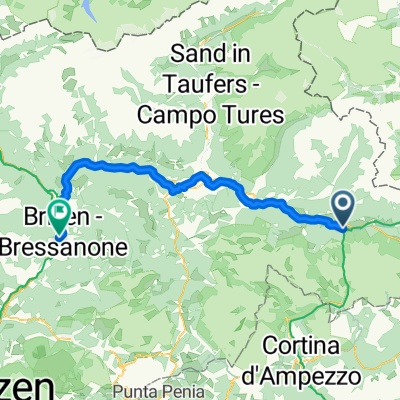
Drava Cycle Route - Toblach to Aich/Dob
A cycling route starting in Toblach, Trentino-Alto Adige, Italy.
Overview
About this route
More about the Drava Cycle Route:
https://www.cyclingthread.com/cycling-in-austria-drava-cycle-route-in-carinthia
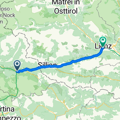
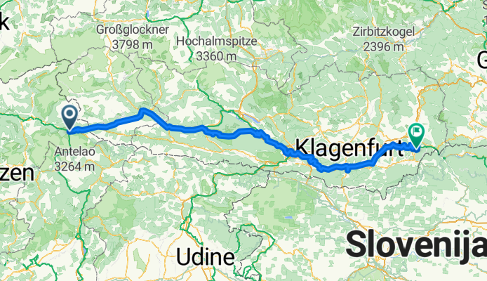
The Drava Cycle Route (Drauradweg) is one of only four European routes awarded the top five-star rating by the ADFC, and its central section through Carinthia shows off some of Austrias most beautiful summer scenery. The full route stretches for about 510 kilometers from Dobbiaco in Italy via Lienz, Villach, Ferlach and Völkermarkt to Aich/Dob in Austria. In Carinthia you ride on well-maintained cycling roads, past lakes and rivers, with views of mountains and stops in historic towns. A highlight is the cycling path that runs 100 meters above the river under the Jauntalbrücke railway bridge. The infrastructure is excellent, with clear signage, bike-friendly accommodation and services coordinated by the Drava Route Hosts Association. Most of the route is easy and flat along the Drava valley, though sporty riders can add climbs like the Weissensee. Altogether the Drava Cycle Route combines scenery, comfort and variety, making it a great choice for a summer cycling trip.
- 18 h 46 min
- Duration
- 288.3 km
- Distance
- 2,961 m
- Ascent
- 3,722 m
- Descent
- 15.4 km/h
- Avg. speed
- 1,240 m
- Max. altitude
Route photos
Continue with Bikemap
Use, edit, or download this cycling route
You would like to ride Drava Cycle Route - Toblach to Aich/Dob or customize it for your own trip? Here is what you can do with this Bikemap route:
Free features
- Save this route as favorite or in collections
- Copy & plan your own version of this route
- Split it into stages to create a multi-day tour
- Sync your route with Garmin or Wahoo
Premium features
Free trial for 3 days, or one-time payment. More about Bikemap Premium.
- Navigate this route on iOS & Android
- Export a GPX / KML file of this route
- Create your custom printout (try it for free)
- Download this route for offline navigation
Discover more Premium features.
Get Bikemap PremiumFrom our community
Other popular routes starting in Toblach
- Drau/Drava - Etappe I
- Distance
- 54.9 km
- Ascent
- 12 m
- Descent
- 565 m
- Location
- Toblach, Trentino-Alto Adige, Italy
- Drauradweg Gesamtstrecke: Toblach-(Varaždin)Legrad
- Distance
- 513.2 km
- Ascent
- 4,683 m
- Descent
- 5,770 m
- Location
- Toblach, Trentino-Alto Adige, Italy
- Un Passo dal Cielo Agosto 2021-Dobbiaco, lago di Braies
- Distance
- 15.7 km
- Ascent
- 502 m
- Descent
- 200 m
- Location
- Toblach, Trentino-Alto Adige, Italy
- From Dobbiaco to Misurina Lake
- Distance
- 21.2 km
- Ascent
- 591 m
- Descent
- 63 m
- Location
- Toblach, Trentino-Alto Adige, Italy
- Markinkele
- Distance
- 51.1 km
- Ascent
- 1,443 m
- Descent
- 1,443 m
- Location
- Toblach, Trentino-Alto Adige, Italy
- Drauradweg Toblach - Lienz
- Distance
- 45.9 km
- Ascent
- 475 m
- Descent
- 1,011 m
- Location
- Toblach, Trentino-Alto Adige, Italy
- Od Lago di Landro přes Bruneck do Nauders
- Distance
- 71.4 km
- Ascent
- 422 m
- Descent
- 828 m
- Location
- Toblach, Trentino-Alto Adige, Italy
- Toblach - Olang - Bruneck - Toblach
- Distance
- 68.4 km
- Ascent
- 606 m
- Descent
- 655 m
- Location
- Toblach, Trentino-Alto Adige, Italy
Open it in the app