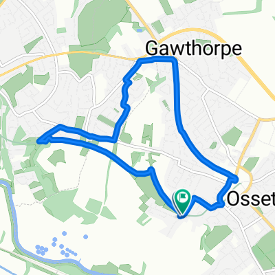
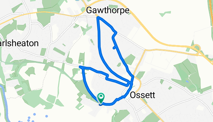
Suffolk Close do Runtlings Lane
A cycling route starting in Ossett, England, United Kingdom.
Overview
About this route
- 34 min
- Duration
- 6.4 km
- Distance
- 64 m
- Ascent
- 111 m
- Descent
- 11.4 km/h
- Avg. speed
- 127 m
- Max. altitude
Route photos
Route quality
Waytypes & surfaces along the route
Waytypes
Road
2.1 km
(32 %)
Busy road
2 km
(31 %)
Surfaces
Paved
3.7 km
(58 %)
Unpaved
0.2 km
(3 %)
Asphalt
3.2 km
(50 %)
Paving stones
0.4 km
(7 %)
Continue with Bikemap
Use, edit, or download this cycling route
You would like to ride Suffolk Close do Runtlings Lane or customize it for your own trip? Here is what you can do with this Bikemap route:
Free features
- Save this route as favorite or in collections
- Copy & plan your own version of this route
- Sync your route with Garmin or Wahoo
Premium features
Free trial for 3 days, or one-time payment. More about Bikemap Premium.
- Navigate this route on iOS & Android
- Export a GPX / KML file of this route
- Create your custom printout (try it for free)
- Download this route for offline navigation
Discover more Premium features.
Get Bikemap PremiumFrom our community
Other popular routes starting in Ossett
- Runtlings Lane do Suffolk Close
- Distance
- 8.8 km
- Ascent
- 83 m
- Descent
- 127 m
- Location
- Ossett, England, United Kingdom
- Suffolk Close do Runtlings Lane
- Distance
- 6.4 km
- Ascent
- 64 m
- Descent
- 111 m
- Location
- Ossett, England, United Kingdom
- Gawthorpe to Thornes Park 190403
- Distance
- 7.6 km
- Ascent
- 32 m
- Descent
- 123 m
- Location
- Ossett, England, United Kingdom
- Bike Ride 1
- Distance
- 17.7 km
- Ascent
- 231 m
- Descent
- 227 m
- Location
- Ossett, England, United Kingdom
- Pippins Green Avenue 33, Kirkhamgate to Calder Row 11, Stanley
- Distance
- 7.7 km
- Ascent
- 54 m
- Descent
- 125 m
- Location
- Ossett, England, United Kingdom
- Gawthorpe to Thornes Park
- Distance
- 6.8 km
- Ascent
- 51 m
- Descent
- 139 m
- Location
- Ossett, England, United Kingdom
- Birchen Avenue 22 to Birchen Avenue 18
- Distance
- 76.9 km
- Ascent
- 1,248 m
- Descent
- 1,211 m
- Location
- Ossett, England, United Kingdom
- Brandy Carr Road 50, Kirkhamgate to Brandy Carr Road 50, Kirkhamgate
- Distance
- 49.5 km
- Ascent
- 328 m
- Descent
- 327 m
- Location
- Ossett, England, United Kingdom
Open it in the app