
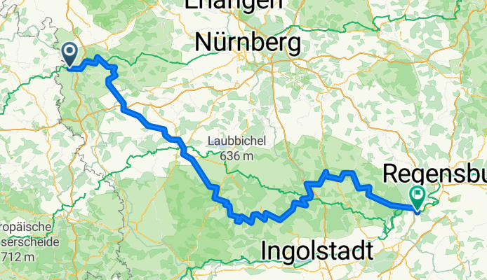
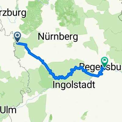
Tauber-Altmühl Cycle Route - Rothenburg ob der Tauber to Kelheim
A cycling route starting in Rothenburg upon Tauber, Bavaria, Germany.
Overview
About this route
More about the Tauber-Altmühl Radweg:
https://www.cyclingthread.com/franconia-and-tauber-altmuhl-radweg-perfect-german-getaway
The Tauber-Altmühl Radweg in Franconia is one of the most fascinating cycling routes in Germany, running through the valleys of the Tauber and Altmühl rivers and the rocky landscapes of the Franconian Jura. Its romantic atmosphere is enhanced by medieval towns, with Rothenburg ob der Tauber standing out as one of the country’s main attractions. The route begins in Wertheim, passes through Rothenburg, and after crossing the European watershed follows the Altmühl to Kelheim, where the river meets the Danube. The Tauber section is about 100 km long, while the Altmühl adds around 250 km, offering varied experiences. Surfaces range from smooth asphalt to gravel paths that fit well into the Jura scenery, even if they are less comfortable. Along the way cyclists can see geological formations like Burgstein, historic bridges in Ornbau, and the Jura Museum in Willibaldsburg Castle in Eichstätt. Altogether, the route combines landscapes, history and good infrastructure, making it an excellent choice for a long weekend or a longer cycling holiday in Franconia.
- 15 h 43 min
- Duration
- 252.2 km
- Distance
- 1,118 m
- Ascent
- 1,200 m
- Descent
- 16 km/h
- Avg. speed
- 510 m
- Max. altitude

Route photos


Continue with Bikemap
Use, edit, or download this cycling route
You would like to ride Tauber-Altmühl Cycle Route - Rothenburg ob der Tauber to Kelheim or customize it for your own trip? Here is what you can do with this Bikemap route:
Free features
- Save this route as favorite or in collections
- Copy & plan your own version of this route
- Split it into stages to create a multi-day tour
- Sync your route with Garmin or Wahoo
Premium features
Free trial for 3 days, or one-time payment. More about Bikemap Premium.
- Navigate this route on iOS & Android
- Export a GPX / KML file of this route
- Create your custom printout (try it for free)
- Download this route for offline navigation
Discover more Premium features.
Get Bikemap PremiumFrom our community
Other popular routes starting in Rothenburg upon Tauber
 Taubertal-Panorama
- Distance
- 52.4 km
- Ascent
- 733 m
- Descent
- 895 m
- Location
- Rothenburg upon Tauber, Bavaria, Germany
 altmühltal
- Distance
- 137.4 km
- Ascent
- 496 m
- Descent
- 540 m
- Location
- Rothenburg upon Tauber, Bavaria, Germany
 Rund um Rothenburg
- Distance
- 23.1 km
- Ascent
- 463 m
- Descent
- 445 m
- Location
- Rothenburg upon Tauber, Bavaria, Germany
 Altmühlradweg: Rothenburg-Kelheim
- Distance
- 244.8 km
- Ascent
- 316 m
- Descent
- 400 m
- Location
- Rothenburg upon Tauber, Bavaria, Germany
 Rothenburg to Bamberg
- Distance
- 120.8 km
- Ascent
- 98 m
- Descent
- 285 m
- Location
- Rothenburg upon Tauber, Bavaria, Germany
 Rothenburg-Regensburg
- Distance
- 263.4 km
- Ascent
- 1,292 m
- Descent
- 1,373 m
- Location
- Rothenburg upon Tauber, Bavaria, Germany
 Rothenburg Burgbernheim Runde
- Distance
- 30.5 km
- Ascent
- 266 m
- Descent
- 275 m
- Location
- Rothenburg upon Tauber, Bavaria, Germany
 35_Rothenburg ob der Tauber – Leutershausen
- Distance
- 41.9 km
- Ascent
- 171 m
- Descent
- 168 m
- Location
- Rothenburg upon Tauber, Bavaria, Germany
Open it in the app