
Paris Basel
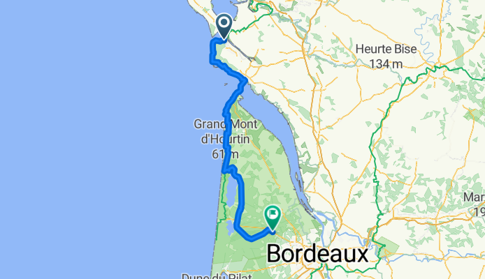
La Tremblade - Sainte-Hélène
A cycling route starting in La Tremblade, Nouvelle-Aquitaine, France.
Overview
About this route
- 9 h 10 min
- Duration
- 152.8 km
- Distance
- 374 m
- Ascent
- 338 m
- Descent
- 16.7 km/h
- Avg. speed
- 53 m
- Max. altitude
Part of
Paris Basel
19 stages
Route quality
Waytypes & surfaces along the route
Waytypes
Cycleway
146.7 km
(96 %)
Quiet road
1.5 km
(1 %)
Surfaces
Paved
117.7 km
(77 %)
Asphalt
97.8 km
(64 %)
Paved (undefined)
18.3 km
(12 %)
Continue with Bikemap
Use, edit, or download this cycling route
You would like to ride La Tremblade - Sainte-Hélène or customize it for your own trip? Here is what you can do with this Bikemap route:
Free features
- Save this route as favorite or in collections
- Copy & plan your own version of this route
- Split it into stages to create a multi-day tour
- Sync your route with Garmin or Wahoo
Premium features
Free trial for 3 days, or one-time payment. More about Bikemap Premium.
- Navigate this route on iOS & Android
- Export a GPX / KML file of this route
- Create your custom printout (try it for free)
- Download this route for offline navigation
Discover more Premium features.
Get Bikemap PremiumFrom our community
Other popular routes starting in La Tremblade
 Atlantique 6
- Distance
- 3.3 km
- Ascent
- 36 m
- Descent
- 33 m
- Location
- La Tremblade, Nouvelle-Aquitaine, France
 8 Ronce Bains - Mortagne-sur-Gironde
- Distance
- 61.2 km
- Ascent
- 346 m
- Descent
- 340 m
- Location
- La Tremblade, Nouvelle-Aquitaine, France
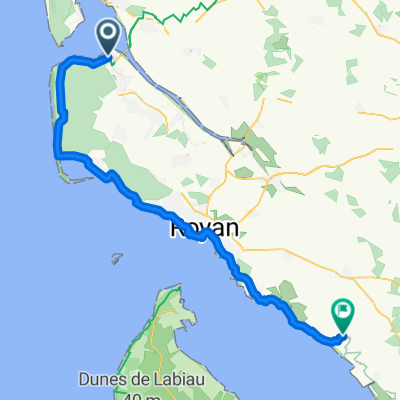
 16 La Tremblade to Royan
- Distance
- 37 km
- Ascent
- 125 m
- Descent
- 121 m
- Location
- La Tremblade, Nouvelle-Aquitaine, France
 Tremblade to Royan
- Distance
- 39.6 km
- Ascent
- 278 m
- Descent
- 279 m
- Location
- La Tremblade, Nouvelle-Aquitaine, France
 St George 1
- Distance
- 73 km
- Ascent
- 166 m
- Descent
- 169 m
- Location
- La Tremblade, Nouvelle-Aquitaine, France
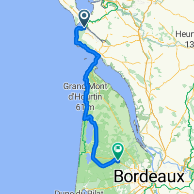 La Tremblade - Sainte-Hélène
- Distance
- 152.8 km
- Ascent
- 374 m
- Descent
- 338 m
- Location
- La Tremblade, Nouvelle-Aquitaine, France
 6 Allée de la Ferme, La Tremblade à 12 Chemin du Pinier, Braud-et-Saint-Louis
- Distance
- 110.7 km
- Ascent
- 899 m
- Descent
- 904 m
- Location
- La Tremblade, Nouvelle-Aquitaine, France
 Ronce - Mornac - Le Gua - St-Just - Marennes 54 km
- Distance
- 53.4 km
- Ascent
- 56 m
- Descent
- 56 m
- Location
- La Tremblade, Nouvelle-Aquitaine, France
Open it in the app