
Von Creglingen bis Brixen
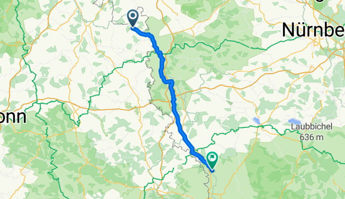
Creglingen - Fremdingen
A cycling route starting in Creglingen, Baden-Wurttemberg, Germany.
Overview
About this route
- 5 h 6 min
- Duration
- 82.5 km
- Distance
- 953 m
- Ascent
- 782 m
- Descent
- 16.2 km/h
- Avg. speed
- 499 m
- Max. altitude
Part of
Von Creglingen bis Brixen
7 stages
Route quality
Waytypes & surfaces along the route
Waytypes
Quiet road
31.3 km
(38 %)
Track
28 km
(34 %)
Surfaces
Paved
53.6 km
(65 %)
Unpaved
8.2 km
(10 %)
Asphalt
50.3 km
(61 %)
Gravel
7.4 km
(9 %)
Continue with Bikemap
Use, edit, or download this cycling route
You would like to ride Creglingen - Fremdingen or customize it for your own trip? Here is what you can do with this Bikemap route:
Free features
- Save this route as favorite or in collections
- Copy & plan your own version of this route
- Split it into stages to create a multi-day tour
- Sync your route with Garmin or Wahoo
Premium features
Free trial for 3 days, or one-time payment. More about Bikemap Premium.
- Navigate this route on iOS & Android
- Export a GPX / KML file of this route
- Create your custom printout (try it for free)
- Download this route for offline navigation
Discover more Premium features.
Get Bikemap PremiumFrom our community
Other popular routes starting in Creglingen
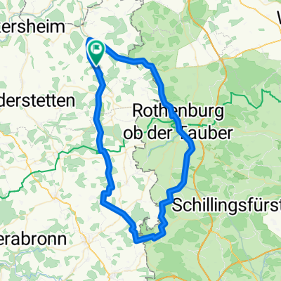
 Creglingen - Rothenburg ob der Tauber
- Distance
- 17.7 km
- Ascent
- 459 m
- Descent
- 358 m
- Location
- Creglingen, Baden-Wurttemberg, Germany
 Tauber-Main_01
- Distance
- 70.8 km
- Ascent
- 675 m
- Descent
- 669 m
- Location
- Creglingen, Baden-Wurttemberg, Germany
 awv60a-Creiglingen-Weikersheim Bhf
- Distance
- 18.4 km
- Ascent
- 135 m
- Descent
- 171 m
- Location
- Creglingen, Baden-Wurttemberg, Germany
 Archshofen (Taubertal) --> Heidelberg (Neckartal)
- Distance
- 173.5 km
- Ascent
- 393 m
- Descent
- 569 m
- Location
- Creglingen, Baden-Wurttemberg, Germany
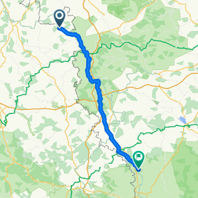 Creglingen - Fremdingen
- Distance
- 82.5 km
- Ascent
- 953 m
- Descent
- 782 m
- Location
- Creglingen, Baden-Wurttemberg, Germany
 Creglingen-Freudenbach-Runde
- Distance
- 18.6 km
- Ascent
- 171 m
- Descent
- 162 m
- Location
- Creglingen, Baden-Wurttemberg, Germany
 Untere Taubertalrunde
- Distance
- 35.4 km
- Ascent
- 334 m
- Descent
- 356 m
- Location
- Creglingen, Baden-Wurttemberg, Germany
 Archshofen - Crailsheim
- Distance
- 42.4 km
- Ascent
- 330 m
- Descent
- 225 m
- Location
- Creglingen, Baden-Wurttemberg, Germany
Open it in the app