
La Vélidéale - E2
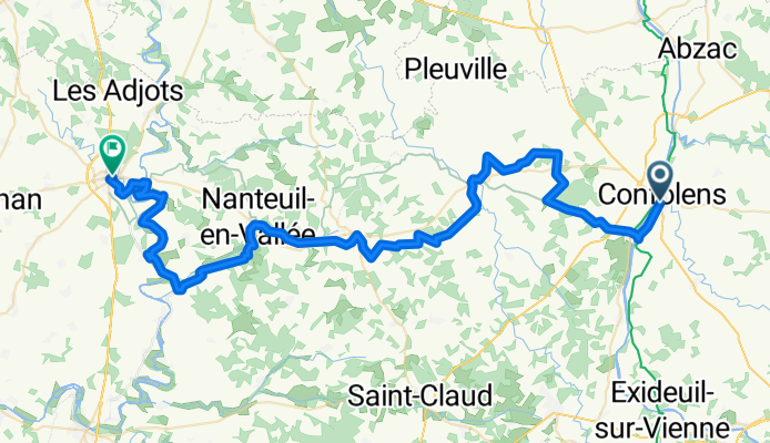
Eissiduelh - Ruffec
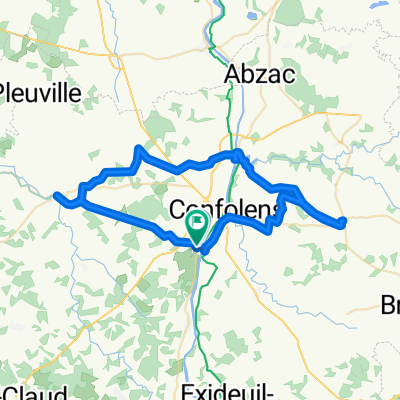
A cycling route starting in Confolens, Nouvelle-Aquitaine, France.
Overview
About this route
- 4 h 25 min
- Duration
- 69.1 km
- Distance
- 654 m
- Ascent
- 712 m
- Descent
- 15.7 km/h
- Avg. speed
- 231 m
- Max. altitude

Part of
La Vélidéale - E2
9 stages
Route quality
Waytypes & surfaces along the route
Waytypes
Quiet road
16.6 km
(24 %)
Road
6.9 km
(10 %)
Surfaces
Paved
2.1 km
(3 %)
Asphalt
2.1 km
(3 %)
Undefined
67 km
(97 %)
Continue with Bikemap
Use, edit, or download this cycling route
You would like to ride Eissiduelh - Ruffec or customize it for your own trip? Here is what you can do with this Bikemap route:
Free features
- Save this route as favorite or in collections
- Copy & plan your own version of this route
- Sync your route with Garmin or Wahoo
Premium features
Free trial for 3 days, or one-time payment. More about Bikemap Premium.
- Navigate this route on iOS & Android
- Export a GPX / KML file of this route
- Create your custom printout (try it for free)
- Download this route for offline navigation
Discover more Premium features.
Get Bikemap PremiumFrom our community
Other popular routes starting in Confolens
 Route in Ansac-sur-Vienne
- Distance
- 57.2 km
- Ascent
- 585 m
- Descent
- 583 m
- Location
- Confolens, Nouvelle-Aquitaine, France
 Confolens to Pressac
- Distance
- 50.2 km
- Ascent
- 447 m
- Descent
- 455 m
- Location
- Confolens, Nouvelle-Aquitaine, France
 9 bis Rue Fontaine de Guimard, Confolens to 11 Rue Fontaine de Guimard, Confolens
- Distance
- 61 km
- Ascent
- 1,018 m
- Descent
- 1,017 m
- Location
- Confolens, Nouvelle-Aquitaine, France
 Confolence to Civray
- Distance
- 88.5 km
- Ascent
- 837 m
- Descent
- 841 m
- Location
- Confolens, Nouvelle-Aquitaine, France
 Schweiz - Atlantik; 10. Etappe Confolens (Camping Municipal) - Bourg Charante (Camping)
- Distance
- 108.7 km
- Ascent
- 734 m
- Descent
- 828 m
- Location
- Confolens, Nouvelle-Aquitaine, France
 Confolens to Augignac
- Distance
- 65.7 km
- Ascent
- 514 m
- Descent
- 369 m
- Location
- Confolens, Nouvelle-Aquitaine, France
 Confolens to La Chapelle-Montbrandeix
- Distance
- 55.5 km
- Ascent
- 584 m
- Descent
- 329 m
- Location
- Confolens, Nouvelle-Aquitaine, France
 Confolens to Etagnac longer
- Distance
- 76.8 km
- Ascent
- 991 m
- Descent
- 986 m
- Location
- Confolens, Nouvelle-Aquitaine, France
Open it in the app