
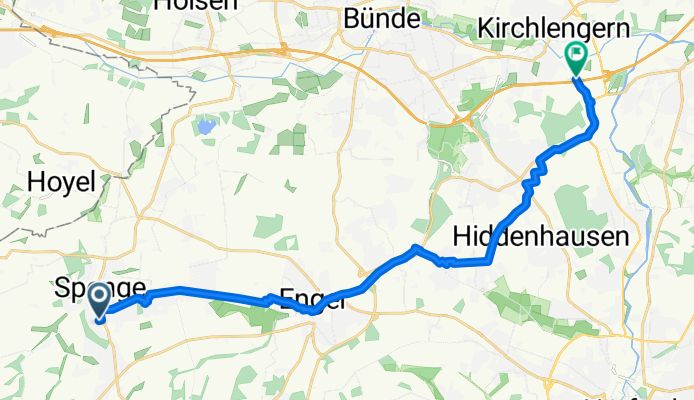
Tannenweg nach Elsestraße
A cycling route starting in Spenge, North Rhine-Westphalia, Germany.
Overview
About this route
- 1 h 13 min
- Duration
- 18.5 km
- Distance
- 81 m
- Ascent
- 173 m
- Descent
- 15.1 km/h
- Avg. speed
- 146 m
- Max. altitude

Route photos


Route quality
Waytypes & surfaces along the route
Waytypes
Path
9.6 km
(52 %)
Quiet road
3.7 km
(20 %)
Surfaces
Paved
13.3 km
(72 %)
Unpaved
2.2 km
(12 %)
Asphalt
13.1 km
(71 %)
Gravel
1.8 km
(10 %)
Continue with Bikemap
Use, edit, or download this cycling route
You would like to ride Tannenweg nach Elsestraße or customize it for your own trip? Here is what you can do with this Bikemap route:
Free features
- Save this route as favorite or in collections
- Copy & plan your own version of this route
- Sync your route with Garmin or Wahoo
Premium features
Free trial for 3 days, or one-time payment. More about Bikemap Premium.
- Navigate this route on iOS & Android
- Export a GPX / KML file of this route
- Create your custom printout (try it for free)
- Download this route for offline navigation
Discover more Premium features.
Get Bikemap PremiumFrom our community
Other popular routes starting in Spenge
 Tannenweg nach Elsestraße
- Distance
- 18.5 km
- Ascent
- 81 m
- Descent
- 173 m
- Location
- Spenge, North Rhine-Westphalia, Germany
 Aufnahme vom 8. November 11:49
- Distance
- 44.5 km
- Ascent
- 378 m
- Descent
- 378 m
- Location
- Spenge, North Rhine-Westphalia, Germany
 Tannenweg nach Griesenbruchstraße 2-4
- Distance
- 10.7 km
- Ascent
- 103 m
- Descent
- 158 m
- Location
- Spenge, North Rhine-Westphalia, Germany
 Enger.Teenhausen,Spenge, Enger
- Distance
- 28.2 km
- Ascent
- 157 m
- Descent
- 159 m
- Location
- Spenge, North Rhine-Westphalia, Germany
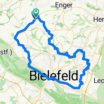 Rund um Bielefeld
- Distance
- 53.8 km
- Ascent
- 244 m
- Descent
- 241 m
- Location
- Spenge, North Rhine-Westphalia, Germany
 Kaiser W. mit Blue Bar
- Distance
- 104.2 km
- Ascent
- 531 m
- Descent
- 532 m
- Location
- Spenge, North Rhine-Westphalia, Germany
 Spenge nach Bünde....
- Distance
- 12.7 km
- Ascent
- 54 m
- Descent
- 80 m
- Location
- Spenge, North Rhine-Westphalia, Germany
 Rundkurs Herford hügelich
- Distance
- 64.6 km
- Ascent
- 412 m
- Descent
- 415 m
- Location
- Spenge, North Rhine-Westphalia, Germany
Open it in the app