

Roßdorf, Lichtenberg, Nonrod, Fränkisch-Crumbach, Fischbachtal, Modautal
A cycling route starting in Roßdorf, Hesse, Germany.
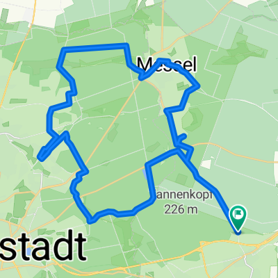
Overview
About this route
The designation 'suitable for road bikes' applies with a small caveat. The path from Nonrod via Bergkam is covered with gravel. Just before the end, there's a fairly steep section that requires some balance and riding skills due to the gravel, so caution is advised. The same applies to the section after Fränkisch-Crumbach, where the path becomes gravelly again at the start of the forest. Right at the beginning, there's a short (approx. 10-20m) steep section, requiring some technical balance. The tour was otherwise a test route, so the path runs through Meßbach and Steinau up to the (southern) end. In Meßbach, it seems to continue paved (both west and east), but how far I do not know. In Steinau, the path turns back into a typical forest/gravel trail at the end, so I did not continue further.
- -:--
- Duration
- 54.2 km
- Distance
- 813 m
- Ascent
- 813 m
- Descent
- ---
- Avg. speed
- ---
- Max. altitude
Route quality
Waytypes & surfaces along the route
Waytypes
Road
11.4 km
(21 %)
Quiet road
11.4 km
(21 %)
Surfaces
Paved
40.1 km
(74 %)
Unpaved
4.3 km
(8 %)
Asphalt
37.4 km
(69 %)
Gravel
3.3 km
(6 %)
Route highlights
Points of interest along the route
Point of interest after 19 km
Ab hier schottriger Weg (wird allerdings auch von Autos befahren)
Point of interest after 20.3 km
Ab hier wieder asphaltiert.
Point of interest after 25.7 km
Ab hier wieder schottriger Weg, komplett durch den Wald.
Continue with Bikemap
Use, edit, or download this cycling route
You would like to ride Roßdorf, Lichtenberg, Nonrod, Fränkisch-Crumbach, Fischbachtal, Modautal or customize it for your own trip? Here is what you can do with this Bikemap route:
Free features
- Save this route as favorite or in collections
- Copy & plan your own version of this route
- Sync your route with Garmin or Wahoo
Premium features
Free trial for 3 days, or one-time payment. More about Bikemap Premium.
- Navigate this route on iOS & Android
- Export a GPX / KML file of this route
- Create your custom printout (try it for free)
- Download this route for offline navigation
Discover more Premium features.
Get Bikemap PremiumFrom our community
Other popular routes starting in Roßdorf
 Rundkurs Messel
- Distance
- 36.1 km
- Ascent
- 212 m
- Descent
- 215 m
- Location
- Roßdorf, Hesse, Germany
 Roßdorf Süd-Ost
- Distance
- 61 km
- Ascent
- 886 m
- Descent
- 894 m
- Location
- Roßdorf, Hesse, Germany
 Roßdorf-Spachbrücken-Groß-Zimmern2
- Distance
- 18.2 km
- Ascent
- 95 m
- Descent
- 80 m
- Location
- Roßdorf, Hesse, Germany
 Feierabendroute Roßdorf
- Distance
- 11.7 km
- Ascent
- 155 m
- Descent
- 172 m
- Location
- Roßdorf, Hesse, Germany
 Im Messler Forst
- Distance
- 33.8 km
- Ascent
- 126 m
- Descent
- 162 m
- Location
- Roßdorf, Hesse, Germany
 Feierabendroute_2
- Distance
- 17 km
- Ascent
- 176 m
- Descent
- 184 m
- Location
- Roßdorf, Hesse, Germany
 Roßdorf, Lichtenberg, Nonrod, Fränkisch-Crumbach, Fischbachtal, Modautal
- Distance
- 54.2 km
- Ascent
- 813 m
- Descent
- 813 m
- Location
- Roßdorf, Hesse, Germany
 Roßdorf-Habitzheim-Lengfeld-Groß-Umstadt
- Distance
- 38.6 km
- Ascent
- 144 m
- Descent
- 207 m
- Location
- Roßdorf, Hesse, Germany
Open it in the app